Urspringen geodata
Urspringen (Bavaria) is a seat of a fourth-order administrative division; located in Germany in Europe/Berlin (GMT+2) time zone. With population of 1,350 people, there are 6182 cities with bigger population in this country. Compared to other cities in Germany, 66.3% of cities are located further ↑North; 54.8% of cities are located further →East and 57.6% of cities have lower elevation than Urspringen. Note1
Administrative division(s):
- Level 1: Bavaria
- Level 2: Regierungsbezirk Unterfranken
- Level 3: Landkreis Main-Spessart
- Level 4: Urspringen


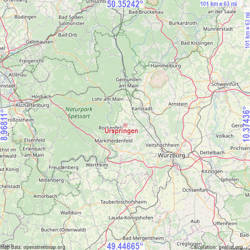
Urspringen GPS coordinates[2]
49° 54' 5.976" North, 9° 40' 16.428" East
| Map corner | latitude | longitude |
|---|---|---|
| Upper-left | 50.35242°, | 8.96811° |
| Center: | 49.90166°, | 9.67123° |
| Lower-right: | 49.44665°, | 10.37436° |
| Map W x H: | 100.7×100.7 km | = 62.6×62.6mi |
| max Lat: | 55.01917° ⇑66.3% North |
| Urspringen: | 49.90166° |
| min Lat: | ⇓33.7% South 47.40724° |
| min Long | Urspringen | max Long |
| 5.92978° | 9.67123° | 14.98853° |
| W 45.2%⇐ | ⇒54.8% E |
Elevation
Elevation of Urspringen is 276 m = 906 ft, and this is 26.9 m = 88 ft above average elevation for this country.
| Max E: |
1256 m = 4121 ft | 42.4% |
| Urspringen | 276 m 906 ft | |
| Avg. | 249.1 m = 817 ft | |
Min E: |
-5 m = -16 ft | 57.6% |
See also: Germany elevation on elevation.city.
Geographical zone
Urspringen is located in North temperate zone (between Tropic of Cancer and the Arctic Circle). Distance of this North polar circle is 1852.6 km =1151.2 mi to North.| Distance of | km | miles | from Urspringen |
|---|---|---|---|
| North Pole | 4458.5 | 2770.4 | to North |
| Arctic Circle | 1852.6 | 1151.2 | to North |
| Tropic Cancer | 2942.6 | 1828.4 | to South |
| Equator | 5548.5 | 3447.7 | to South |


Nearby cities:
15 places around Urspringen: (largest is in red/bold)
• Birkenfeld
5.1 km =3.2 mi,  159°
159°
• Erlenbach
8.8 km =5.5 mi,  347°
347°
• Esselbach
11.6 km =7.2 mi,  243°
243°
• Greußenheim
11.7 km =7.3 mi,  144°
144°
• Hafenlohr
6.1 km =3.8 mi,  234°
234°
• Himmelstadt
9.7 km =6 mi,  75°
75°
• Karbach
4.5 km =2.8 mi,  211°
211°
• Karlstadt
9.7 km =6 mi,  47°
47°
• Marktheidenfeld
7.9 km =4.9 mi,  217°
217°
• Neustadt am Main
8 km =5 mi,  293°
293°
• Remlingen
10.9 km =6.8 mi,  171°
171°
• Roden
3.3 km =2.1 mi,  258°
258°
• Rothenfels
5.7 km =3.5 mi, 258°
• Steinfeld
5.7 km =3.5 mi,  358°
358°
• Zellingen
10.5 km =6.5 mi,  92°
92°
Sources, notices
• [Note1] Compared only with cities in Germany existing in our database
• [Src1] Map data: © OpenStreetMap contributors (CC-BY-SA)
• [Src2] Other city data from geonames.org with taken over terms of usage.
• [Src3] Geographical zone / Annual Mean Temperature by Robert A. Rohde @ Wikipedia
