Kanzach geodata
Kanzach (Baden-Württemberg) is a seat of a fourth-order administrative division; located in Germany in Europe/Berlin (GMT+2) time zone. With population of 520 people, there are 9251 cities with bigger population in this country. Compared to other cities in Germany, 94.3% of cities are located further ↑North; 56.9% of cities are located further →East and 93.9% of cities have lower elevation than Kanzach. Note1
Administrative division(s):
- Level 1: Baden-Württemberg
- Level 2: Tübingen Region
- Level 3: Landkreis Biberach
- Level 4: Kanzach


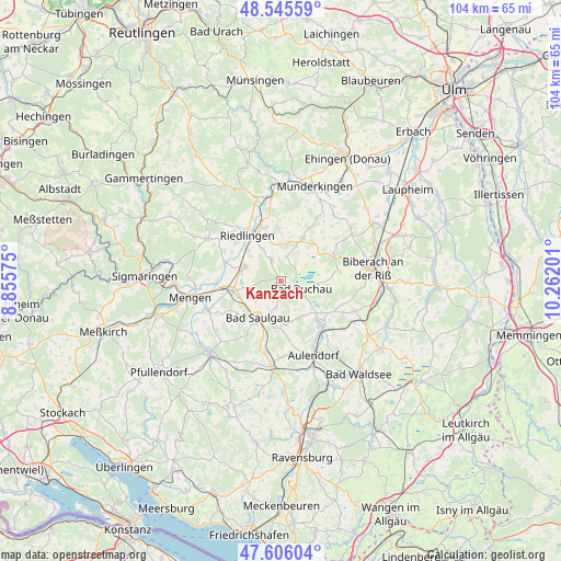
Kanzach GPS coordinates[2]
48° 4' 40.656" North, 9° 33' 31.968" East
| Map corner | latitude | longitude |
|---|---|---|
| Upper-left | 48.54559°, | 8.85575° |
| Center: | 48.07796°, | 9.55888° |
| Lower-right: | 47.60604°, | 10.26201° |
| Map W x H: | 104.5×104.5 km | = 64.9×64.9mi |
| max Lat: | 55.01917° ⇑94.3% North |
| Kanzach: | 48.07796° |
| min Lat: | ⇓5.7% South 47.40724° |
| min Long | Kanzach | max Long |
| 5.92978° | 9.55888° | 14.98853° |
| W 43.1%⇐ | ⇒56.9% E |
Elevation
Elevation of Kanzach is 573 m = 1880 ft, and this is 323.9 m = 1063 ft above average elevation for this country.
| Max E: |
1256 m = 4121 ft | 6.1% |
| Kanzach | 573 m 1880 ft | |
| Avg. | 249.1 m = 817 ft | |
Min E: |
-5 m = -16 ft | 93.9% |
See also: Germany elevation on elevation.city.
Geographical zone
Kanzach is located in North temperate zone (between Tropic of Cancer and the Arctic Circle). Distance of this North polar circle is 2055.4 km =1277.2 mi to North.| Distance of | km | miles | from Kanzach |
|---|---|---|---|
| North Pole | 4661.3 | 2896.4 | to North |
| Arctic Circle | 2055.4 | 1277.2 | to North |
| Tropic Cancer | 2739.8 | 1702.4 | to South |
| Equator | 5345.8 | 3321.7 | to South |


Nearby cities:
15 places around Kanzach: (largest is in red/bold)
• Alleshausen
5.5 km =3.4 mi,  58°
58°
• Allmannsweiler
6.1 km =3.8 mi,  154°
154°
• Bad Buchau
4.3 km =2.7 mi,  113°
113°
• Betzenweiler
4.3 km =2.7 mi,  7°
7°
• Dürmentingen
4.7 km =2.9 mi,  336°
336°
• Dürnau
2 km =1.2 mi,  187°
187°
• Ertingen
7.3 km =4.5 mi,  289°
289°
• Herbertingen
9.4 km =5.8 mi,  262°
262°
• Neufra
8.4 km =5.2 mi,  312°
312°
• Oggelshausen
6.9 km =4.3 mi,  100°
100°
• Saulgau
8.1 km =5 mi,  212°
212°
• Seekirch
7.2 km =4.5 mi,  70°
70°
• Tiefenbach
6.8 km =4.2 mi,  84°
84°
• Unlingen
10.3 km =6.4 mi, 344°
• Uttenweiler
9.1 km =5.7 mi,  28°
28°
Sources, notices
• [Note1] Compared only with cities in Germany existing in our database
• [Src1] Map data: © OpenStreetMap contributors (CC-BY-SA)
• [Src2] Other city data from geonames.org with taken over terms of usage.
• [Src3] Geographical zone / Annual Mean Temperature by Robert A. Rohde @ Wikipedia
