Allmannsweiler geodata
Allmannsweiler (Baden-Württemberg) is a seat of a fourth-order administrative division; located in Germany in Europe/Berlin (GMT+2) time zone. With population of 333 people, there are 9931 cities with bigger population in this country. Compared to other cities in Germany, 95.1% of cities are located further ↑North; 56.3% of cities are located further →East and 95.9% of cities have lower elevation than Allmannsweiler. Note1
Administrative division(s):
- Level 1: Baden-Württemberg
- Level 2: Tübingen Region
- Level 3: Landkreis Biberach
- Level 4: Allmannsweiler


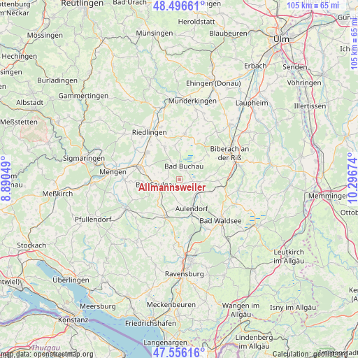
Allmannsweiler GPS coordinates[2]
48° 1' 42.708" North, 9° 35' 36.996" East
| Map corner | latitude | longitude |
|---|---|---|
| Upper-left | 48.49661°, | 8.89049° |
| Center: | 48.02853°, | 9.59361° |
| Lower-right: | 47.55616°, | 10.29674° |
| Map W x H: | 104.6×104.6 km | = 65×65mi |
| max Lat: | 55.01917° ⇑95.1% North |
| Allmannsweiler: | 48.02853° |
| min Lat: | ⇓4.9% South 47.40724° |
| min Long | Allmannsweiler | max Long |
| 5.92978° | 9.59361° | 14.98853° |
| W 43.7%⇐ | ⇒56.3% E |
Elevation
Elevation of Allmannsweiler is 624 m = 2047 ft, and this is 374.9 m = 1230 ft above average elevation for this country.
| Max E: |
1256 m = 4121 ft | 4.1% |
| Allmannsweiler | 624 m 2047 ft | |
| Avg. | 249.1 m = 817 ft | |
Min E: |
-5 m = -16 ft | 95.9% |
See also: Germany elevation on elevation.city.
Geographical zone
Allmannsweiler is located in North temperate zone (between Tropic of Cancer and the Arctic Circle). Distance of this North polar circle is 2060.9 km =1280.6 mi to North.| Distance of | km | miles | from Allmannsweiler |
|---|---|---|---|
| North Pole | 4666.8 | 2899.8 | to North |
| Arctic Circle | 2060.9 | 1280.6 | to North |
| Tropic Cancer | 2734.4 | 1699.1 | to South |
| Equator | 5340.3 | 3318.3 | to South |


Nearby cities:
15 places around Allmannsweiler: (largest is in red/bold)
• Alleshausen
8.6 km =5.3 mi,  14°
14°
• Aulendorf
9.2 km =5.7 mi,  159°
159°
• Bad Buchau
4 km =2.5 mi,  20°
20°
• Bad Schussenried
5.4 km =3.4 mi,  119°
119°
• Betzenweiler
10 km =6.2 mi,  348°
348°
• Boms
8.2 km =5.1 mi,  224°
224°
• Dürmentingen
10.8 km =6.7 mi,  335°
335°
• Dürnau
4.5 km =2.8 mi,  321°
321°
• Ebersbach-Musbach
6.9 km =4.3 mi,  186°
186°
• Ingoldingen
11 km =6.8 mi,  91°
91°
• Kanzach
6.1 km =3.8 mi,  334°
334°
• Oggelshausen
6 km =3.7 mi,  44°
44°
• Saulgau
7 km =4.3 mi,  259°
259°
• Seekirch
9 km =5.6 mi,  27°
27°
• Tiefenbach
7.4 km =4.6 mi, 34°
Sources, notices
• [Note1] Compared only with cities in Germany existing in our database
• [Src1] Map data: © OpenStreetMap contributors (CC-BY-SA)
• [Src2] Other city data from geonames.org with taken over terms of usage.
• [Src3] Geographical zone / Annual Mean Temperature by Robert A. Rohde @ Wikipedia
