Rain geodata
Rain (Bavaria) is a populated place; located in Germany in Europe/Berlin (GMT+2) time zone. With population of 8,438 people, there are 1886 cities with bigger population in this country. Compared to other cities in Germany, 86.6% of cities are located further ↑North; 65.7% of cities are located further ←West and 76.7% of cities have lower elevation than Rain. Note1
Administrative division(s):
- Level 1: Bavaria
- Level 2: Swabia
- Level 3: Landkreis Donau-Ries
- Level 4: Rain


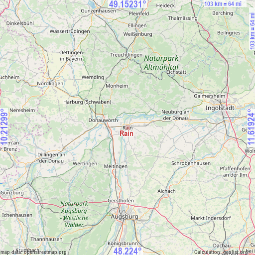
Rain GPS coordinates[2]
48° 41' 25.044" North, 10° 54' 57.996" East
| Map corner | latitude | longitude |
|---|---|---|
| Upper-left | 49.15231°, | 10.21299° |
| Center: | 48.69029°, | 10.91611° |
| Lower-right: | 48.224°, | 11.61924° |
| Map W x H: | 103.2×103.2 km | = 64.1×64.1mi |
| max Lat: | 55.01917° ⇑86.6% North |
| Rain: | 48.69029° |
| min Lat: | ⇓13.4% South 47.40724° |
| min Long | Rain | max Long |
| 5.92978° | 10.91611° | 14.98853° |
| W 65.7%⇐ | ⇒34.3% E |
Elevation
Elevation of Rain is 410 m = 1345 ft, and this is 160.9 m = 528 ft above average elevation for this country.
| Max E: |
1256 m = 4121 ft | 23.3% |
| Rain | 410 m 1345 ft | |
| Avg. | 249.1 m = 817 ft | |
Min E: |
-5 m = -16 ft | 76.7% |
See also: Germany elevation on elevation.city.
Geographical zone
Rain is located in North temperate zone (between Tropic of Cancer and the Arctic Circle). Distance of this North polar circle is 1987.3 km =1234.9 mi to North.| Distance of | km | miles | from Rain |
|---|---|---|---|
| North Pole | 4593.2 | 2854.1 | to North |
| Arctic Circle | 1987.3 | 1234.9 | to North |
| Tropic Cancer | 2807.9 | 1744.7 | to South |
| Equator | 5413.9 | 3364 | to South |


Nearby cities:
15 places around Rain: (largest is in red/bold)
• Allmannshofen
11.7 km =7.3 mi,  222°
222°
• Asbach-Bäumenheim
7.3 km =4.5 mi,  263°
263°
• Buchdorf
12 km =7.5 mi,  329°
329°
• Burgheim
7.4 km =4.6 mi,  81°
81°
• Daiting
11.3 km =7 mi,  355°
355°
• Donauwörth
10.5 km =6.5 mi,  287°
287°
• Ellgau
10.7 km =6.6 mi,  199°
199°
• Genderkingen
2.6 km =1.6 mi, 294°
• Holzheim
9.1 km =5.7 mi,  164°
164°
• Marxheim
6.1 km =3.8 mi,  20°
20°
• Mertingen
8.9 km =5.5 mi,  245°
245°
• Münster
7.6 km =4.7 mi,  187°
187°
• Niederschönenfeld
3.2 km =2 mi, 23°
• Oberndorf
4.3 km =2.7 mi,  236°
236°
• Rennertshofen
12.2 km =7.6 mi,  50°
50°
Sources, notices
• [Note1] Compared only with cities in Germany existing in our database
• [Src1] Map data: © OpenStreetMap contributors (CC-BY-SA)
• [Src2] Other city data from geonames.org with taken over terms of usage.
• [Src3] Geographical zone / Annual Mean Temperature by Robert A. Rohde @ Wikipedia
