Mertingen geodata
Mertingen (Bavaria) is a seat of a fourth-order administrative division; located in Germany in Europe/Berlin (GMT+2) time zone. With population of 3,748 people, there are 3441 cities with bigger population in this country. Compared to other cities in Germany, 87% of cities are located further ↑North; 64.1% of cities are located further ←West and 77% of cities have lower elevation than Mertingen. Note1
Administrative division(s):
- Level 1: Bavaria
- Level 2: Swabia
- Level 3: Landkreis Donau-Ries
- Level 4: Mertingen


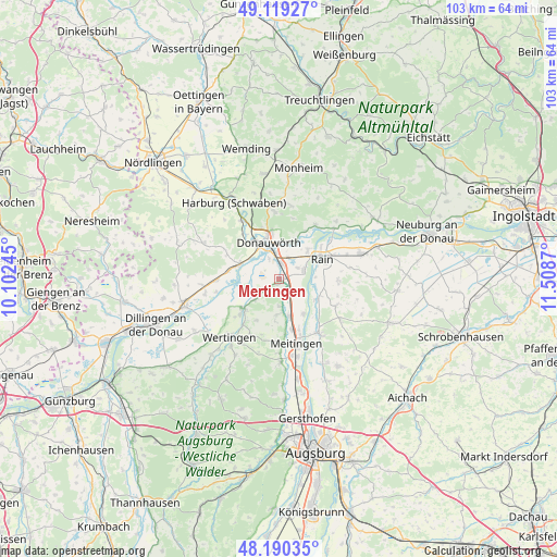
Mertingen GPS coordinates[2]
48° 39' 25.02" North, 10° 48' 20.052" East
| Map corner | latitude | longitude |
|---|---|---|
| Upper-left | 49.11927°, | 10.10245° |
| Center: | 48.65695°, | 10.80557° |
| Lower-right: | 48.19035°, | 11.5087° |
| Map W x H: | 103.3×103.3 km | = 64.2×64.2mi |
| max Lat: | 55.01917° ⇑87% North |
| Mertingen: | 48.65695° |
| min Lat: | ⇓13% South 47.40724° |
| min Long | Mertingen | max Long |
| 5.92978° | 10.80557° | 14.98853° |
| W 64.1%⇐ | ⇒35.9% E |
Elevation
Elevation of Mertingen is 412 m = 1352 ft, and this is 162.9 m = 534 ft above average elevation for this country.
| Max E: |
1256 m = 4121 ft | 23% |
| Mertingen | 412 m 1352 ft | |
| Avg. | 249.1 m = 817 ft | |
Min E: |
-5 m = -16 ft | 77% |
See also: Germany elevation on elevation.city.
Geographical zone
Mertingen is located in North temperate zone (between Tropic of Cancer and the Arctic Circle). Distance of this North polar circle is 1991 km =1237.1 mi to North.| Distance of | km | miles | from Mertingen |
|---|---|---|---|
| North Pole | 4596.9 | 2856.4 | to North |
| Arctic Circle | 1991 | 1237.1 | to North |
| Tropic Cancer | 2804.2 | 1742.4 | to South |
| Equator | 5410.1 | 3361.7 | to South |


Nearby cities:
15 places around Mertingen: (largest is in red/bold)
• Allmannshofen
4.9 km =3 mi,  176°
176°
• Asbach-Bäumenheim
3 km =1.9 mi,  15°
15°
• Buttenwiesen
9.1 km =5.7 mi,  225°
225°
• Donauwörth
7.1 km =4.4 mi,  344°
344°
• Ehingen
6.3 km =3.9 mi, 183°
• Ellgau
7.8 km =4.8 mi,  144°
144°
• Genderkingen
7.5 km =4.7 mi,  50°
50°
• Kühlenthal
10.1 km =6.3 mi, 175°
• Münster
8 km =5 mi,  118°
118°
• Niederschönenfeld
11.5 km =7.1 mi, 54°
• Nordendorf
7.2 km =4.5 mi,  164°
164°
• Oberndorf
4.7 km =2.9 mi,  73°
73°
• Rain
8.9 km =5.5 mi, 65°
• Tapfheim
9.1 km =5.7 mi,  281°
281°
• Westendorf
9.8 km =6.1 mi, 164°
Sources, notices
• [Note1] Compared only with cities in Germany existing in our database
• [Src1] Map data: © OpenStreetMap contributors (CC-BY-SA)
• [Src2] Other city data from geonames.org with taken over terms of usage.
• [Src3] Geographical zone / Annual Mean Temperature by Robert A. Rohde @ Wikipedia
