Julbach geodata
Julbach (Bavaria) is a seat of a fourth-order administrative division; located in Germany in Europe/Berlin (GMT+2) time zone. With population of 2,317 people, there are 4651 cities with bigger population in this country. Compared to other cities in Germany, 91.9% of cities are located further ↑North; 92% of cities are located further ←West and 71.3% of cities have lower elevation than Julbach. Note1
Administrative division(s):
- Level 1: Bavaria
- Level 2: Lower Bavaria
- Level 3: Landkreis Rottal-Inn
- Level 4: Julbach


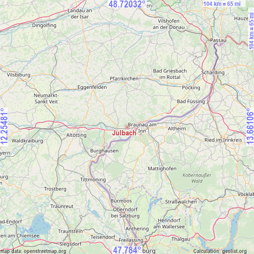
Julbach GPS coordinates[2]
48° 15' 15.48" North, 12° 57' 28.548" East
| Map corner | latitude | longitude |
|---|---|---|
| Upper-left | 48.72032°, | 12.25481° |
| Center: | 48.2543°, | 12.95793° |
| Lower-right: | 47.784°, | 13.66106° |
| Map W x H: | 104.1×104.1 km | = 64.7×64.7mi |
| max Lat: | 55.01917° ⇑91.9% North |
| Julbach: | 48.2543° |
| min Lat: | ⇓8.1% South 47.40724° |
| min Long | Julbach | max Long |
| 5.92978° | 12.95793° | 14.98853° |
| W 92%⇐ | ⇒8% E |
Elevation
Elevation of Julbach is 368 m = 1207 ft, and this is 118.9 m = 390 ft above average elevation for this country.
| Max E: |
1256 m = 4121 ft | 28.7% |
| Julbach | 368 m 1207 ft | |
| Avg. | 249.1 m = 817 ft | |
Min E: |
-5 m = -16 ft | 71.3% |
See also: Germany elevation on elevation.city.
Geographical zone
Julbach is located in North temperate zone (between Tropic of Cancer and the Arctic Circle). Distance of this North polar circle is 2035.8 km =1265 mi to North.| Distance of | km | miles | from Julbach |
|---|---|---|---|
| North Pole | 4641.7 | 2884.2 | to North |
| Arctic Circle | 2035.8 | 1265 | to North |
| Tropic Cancer | 2759.5 | 1714.7 | to South |
| Equator | 5365.4 | 3333.9 | to South |


Nearby cities:
15 places around Julbach: (largest is in red/bold)
• Burghausen
13.3 km =8.3 mi,  224°
224°
• Ering
15.1 km =9.4 mi,  70°
70°
• Erlbach
13.9 km =8.6 mi,  291°
291°
• Haiming
6 km =3.7 mi,  225°
225°
• Kirchdorf am Inn
2.1 km =1.3 mi,  110°
110°
• Marktl
8.4 km =5.2 mi,  270°
270°
• Mehring
15.2 km =9.4 mi,  238°
238°
• Perach
14.2 km =8.8 mi,  275°
275°
• Reut
7.2 km =4.5 mi,  345°
345°
• Simbach am Inn
5 km =3.1 mi,  75°
75°
• Stammham
5.5 km =3.4 mi, 265°
• Stubenberg
11.6 km =7.2 mi,  53°
53°
• Tann
8.3 km =5.2 mi,  324°
324°
• Wittibreut
8.6 km =5.3 mi,  14°
14°
• Zeilarn
9.9 km =6.2 mi,  300°
300°
Sources, notices
• [Note1] Compared only with cities in Germany existing in our database
• [Src1] Map data: © OpenStreetMap contributors (CC-BY-SA)
• [Src2] Other city data from geonames.org with taken over terms of usage.
• [Src3] Geographical zone / Annual Mean Temperature by Robert A. Rohde @ Wikipedia
