Burghausen geodata
Burghausen (Bavaria) is a populated place; located in Germany in Europe/Berlin (GMT+2) time zone. With population of 18,263 people, there are 863 cities with bigger population in this country. Compared to other cities in Germany, 93.1% of cities are located further ↑North; 91% of cities are located further ←West and 78.3% of cities have lower elevation than Burghausen. Note1
Administrative division(s):
- Level 1: Bavaria
- Level 2: Upper Bavaria
- Level 3: Landkreis Altötting
- Level 4: Burghausen


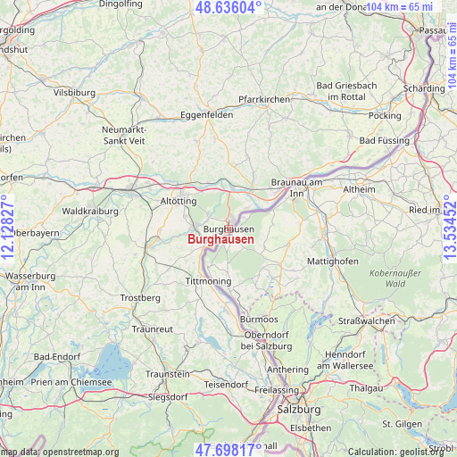
Burghausen GPS coordinates[2]
48° 10' 9.3" North, 12° 49' 53.004" East
| Map corner | latitude | longitude |
|---|---|---|
| Upper-left | 48.63604°, | 12.12827° |
| Center: | 48.16925°, | 12.83139° |
| Lower-right: | 47.69817°, | 13.53452° |
| Map W x H: | 104.3×104.3 km | = 64.8×64.8mi |
| max Lat: | 55.01917° ⇑93.1% North |
| Burghausen: | 48.16925° |
| min Lat: | ⇓6.9% South 47.40724° |
| min Long | Burghausen | max Long |
| 5.92978° | 12.83139° | 14.98853° |
| W 91%⇐ | ⇒9% E |
Elevation
Elevation of Burghausen is 422 m = 1385 ft, and this is 172.9 m = 567 ft above average elevation for this country.
| Max E: |
1256 m = 4121 ft | 21.7% |
| Burghausen | 422 m 1385 ft | |
| Avg. | 249.1 m = 817 ft | |
Min E: |
-5 m = -16 ft | 78.3% |
See also: Germany elevation on elevation.city.
Geographical zone
Burghausen is located in North temperate zone (between Tropic of Cancer and the Arctic Circle). Distance of this North polar circle is 2045.3 km =1270.9 mi to North.| Distance of | km | miles | from Burghausen |
|---|---|---|---|
| North Pole | 4651.1 | 2890.1 | to North |
| Arctic Circle | 2045.3 | 1270.9 | to North |
| Tropic Cancer | 2750 | 1708.8 | to South |
| Equator | 5355.9 | 3328 | to South |


Nearby cities:
15 places around Burghausen: (largest is in red/bold)
• Altötting
13.1 km =8.1 mi,  298°
298°
• Burgkirchen an der Alz
7.3 km =4.5 mi,  268°
268°
• Erlbach
15 km =9.3 mi,  346°
346°
• Haiming
7.3 km =4.5 mi,  43°
43°
• Halsbach
11.7 km =7.3 mi,  250°
250°
• Julbach
13.3 km =8.3 mi, 44°
• Kastl
10.3 km =6.4 mi,  289°
289°
• Kirchdorf am Inn
14.3 km =8.9 mi,  52°
52°
• Marktl
9.6 km =6 mi,  5°
5°
• Mehring
3.9 km =2.4 mi, 293°
• Neuötting
13.2 km =8.2 mi,  307°
307°
• Perach
11.8 km =7.3 mi,  336°
336°
• Stammham
9.8 km =6.1 mi,  23°
23°
• Tittmoning
12.9 km =8 mi,  201°
201°
• Zeilarn
14.6 km =9.1 mi,  3°
3°
Sources, notices
• [Note1] Compared only with cities in Germany existing in our database
• [Src1] Map data: © OpenStreetMap contributors (CC-BY-SA)
• [Src2] Other city data from geonames.org with taken over terms of usage.
• [Src3] Geographical zone / Annual Mean Temperature by Robert A. Rohde @ Wikipedia
