Mehring geodata
Mehring (Bavaria) is a seat of a fourth-order administrative division; located in Germany in Europe/Berlin (GMT+2) time zone. With population of 2,242 people, there are 4755 cities with bigger population in this country. Compared to other cities in Germany, 92.9% of cities are located further ↑North; 90.6% of cities are located further ←West and 77% of cities have lower elevation than Mehring. Note1
Administrative division(s):
- Level 1: Bavaria
- Level 2: Upper Bavaria
- Level 3: Landkreis Altötting
- Level 4: Mehring


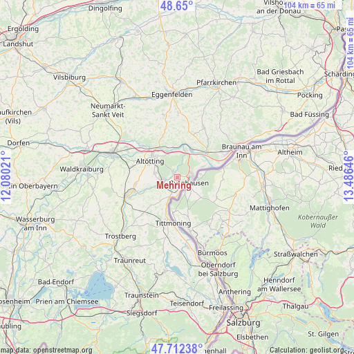
Mehring GPS coordinates[2]
48° 10' 59.988" North, 12° 46' 59.988" East
| Map corner | latitude | longitude |
|---|---|---|
| Upper-left | 48.65°, | 12.08021° |
| Center: | 48.18333°, | 12.78333° |
| Lower-right: | 47.71238°, | 13.48646° |
| Map W x H: | 104.3×104.3 km | = 64.8×64.8mi |
| max Lat: | 55.01917° ⇑92.9% North |
| Mehring: | 48.18333° |
| min Lat: | ⇓7.1% South 47.40724° |
| min Long | Mehring | max Long |
| 5.92978° | 12.78333° | 14.98853° |
| W 90.6%⇐ | ⇒9.4% E |
Elevation
Elevation of Mehring is 412 m = 1352 ft, and this is 162.9 m = 534 ft above average elevation for this country.
| Max E: |
1256 m = 4121 ft | 23% |
| Mehring | 412 m 1352 ft | |
| Avg. | 249.1 m = 817 ft | |
Min E: |
-5 m = -16 ft | 77% |
See also: Germany elevation on elevation.city.
Geographical zone
Mehring is located in North temperate zone (between Tropic of Cancer and the Arctic Circle). Distance of this North polar circle is 2043.7 km =1269.9 mi to North.| Distance of | km | miles | from Mehring |
|---|---|---|---|
| North Pole | 4649.6 | 2889.1 | to North |
| Arctic Circle | 2043.7 | 1269.9 | to North |
| Tropic Cancer | 2751.6 | 1709.8 | to South |
| Equator | 5357.5 | 3329 | to South |


Nearby cities:
15 places around Mehring: (largest is in red/bold)
• Altötting
9.2 km =5.7 mi,  300°
300°
• Burghausen
3.9 km =2.4 mi,  113°
113°
• Burgkirchen an der Alz
4.2 km =2.6 mi,  245°
245°
• Erlbach
13 km =8.1 mi,  0°
0°
• Haiming
9.4 km =5.8 mi,  66°
66°
• Halsbach
9.3 km =5.8 mi,  233°
233°
• Kastl
6.4 km =4 mi,  286°
286°
• Marktl
9.2 km =5.7 mi,  29°
29°
• Neuötting
9.4 km =5.8 mi,  312°
312°
• Perach
9.3 km =5.8 mi,  352°
352°
• Reischach
12.7 km =7.9 mi,  340°
340°
• Stammham
10.5 km =6.5 mi,  44°
44°
• Tittmoning
13.6 km =8.5 mi,  184°
184°
• Unterneukirchen
12.5 km =7.8 mi,  261°
261°
• Winhöring
13.5 km =8.4 mi, 313°
Sources, notices
• [Note1] Compared only with cities in Germany existing in our database
• [Src1] Map data: © OpenStreetMap contributors (CC-BY-SA)
• [Src2] Other city data from geonames.org with taken over terms of usage.
• [Src3] Geographical zone / Annual Mean Temperature by Robert A. Rohde @ Wikipedia
