Jameln geodata
Jameln (Lower Saxony) is a seat of a fourth-order administrative division; located in Germany in Europe/Berlin (GMT+2) time zone. With population of 1,095 people, there are 6860 cities with bigger population in this country. Compared to other cities in Germany, 82% of cities are located further ↓South; 68.1% of cities are located further ←West and 87.3% of cities have higher elevation than Jameln. Note1
Administrative division(s):
- Level 1: Lower Saxony
- Level 3: Landkreis Lüchow-Dannenberg
- Level 4: Jameln


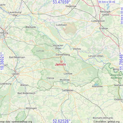
Jameln GPS coordinates[2]
53° 3' 0" North, 11° 4' 59.988" East
| Map corner | latitude | longitude |
|---|---|---|
| Upper-left | 53.47059°, | 10.38021° |
| Center: | 53.05°, | 11.08333° |
| Lower-right: | 52.62526°, | 11.78646° |
| Map W x H: | 94×94 km | = 58.4×58.4mi |
| max Lat: | 55.01917° ⇑18% North |
| Jameln: | 53.05° |
| min Lat: | ⇓82% South 47.40724° |
| min Long | Jameln | max Long |
| 5.92978° | 11.08333° | 14.98853° |
| W 68.1%⇐ | ⇒31.9% E |
Elevation
Elevation of Jameln is 29 m = 95 ft, and this is 220.1 m = 722 ft below average elevation for this country.
| Max E: |
1256 m = 4121 ft | 87.3% |
| Avg. | 249.1 m = 817 ft | |
| Jameln | 29 m = 95 ft | |
Min E: |
-5 m = -16 ft | 12.7% |
See also: Germany elevation on elevation.city.
Geographical zone
Jameln is located in North temperate zone (between Tropic of Cancer and the Arctic Circle). Distance of this North polar circle is 1502.6 km =933.7 mi to North.| Distance of | km | miles | from Jameln |
|---|---|---|---|
| North Pole | 4108.5 | 2552.9 | to North |
| Arctic Circle | 1502.6 | 933.7 | to North |
| Tropic Cancer | 3292.7 | 2046 | to South |
| Equator | 5898.6 | 3665.2 | to South |


Nearby cities:
15 places around Jameln: (largest is in red/bold)
• Clenze
15.1 km =9.4 mi,  213°
213°
• Damnatz
11.5 km =7.1 mi,  33°
33°
• Dannenberg
5.2 km =3.2 mi,  4°
4°
• Dömitz
15 km =9.3 mi,  47°
47°
• Hitzacker
11.7 km =7.3 mi,  347°
347°
• Karwitz
5.8 km =3.6 mi,  309°
309°
• Klein Gusborn
8.2 km =5.1 mi,  63°
63°
• Küsten
8.2 km =5.1 mi,  189°
189°
• Langendorf
12.8 km =8 mi, 63°
• Luckau
13.8 km =8.6 mi, 189°
• Lüchow
10.3 km =6.4 mi,  152°
152°
• Waddeweitz
9.6 km =6 mi,  234°
234°
• Woltersdorf
14.3 km =8.9 mi,  141°
141°
• Wustrow
14.4 km =8.9 mi,  167°
167°
• Zernien
13.5 km =8.4 mi,  278°
278°
Sources, notices
• [Note1] Compared only with cities in Germany existing in our database
• [Src1] Map data: © OpenStreetMap contributors (CC-BY-SA)
• [Src2] Other city data from geonames.org with taken over terms of usage.
• [Src3] Geographical zone / Annual Mean Temperature by Robert A. Rohde @ Wikipedia
