Waddeweitz geodata
Waddeweitz (Lower Saxony) is a seat of a fourth-order administrative division; located in Germany in Europe/Berlin (GMT+2) time zone. With population of 942 people, there are 7380 cities with bigger population in this country. Compared to other cities in Germany, 81.7% of cities are located further ↓South; 66.4% of cities are located further ←West and 80.2% of cities have higher elevation than Waddeweitz. Note1
Administrative division(s):
- Level 1: Lower Saxony
- Level 3: Landkreis Lüchow-Dannenberg
- Level 4: Waddeweitz


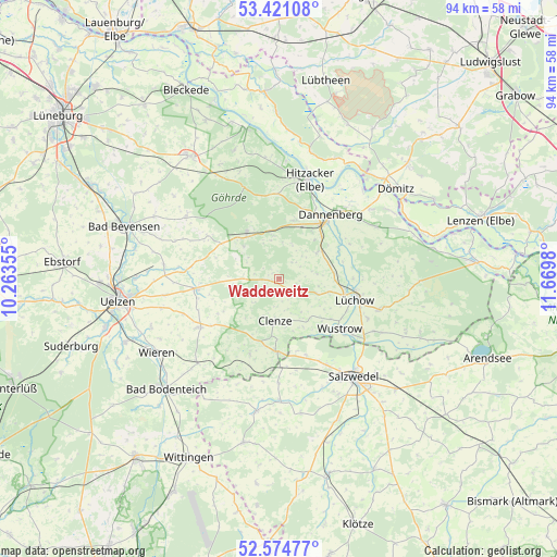
Waddeweitz GPS coordinates[2]
53° 0' 0" North, 10° 58' 0.012" East
| Map corner | latitude | longitude |
|---|---|---|
| Upper-left | 53.42108°, | 10.26355° |
| Center: | 53°, | 10.96667° |
| Lower-right: | 52.57477°, | 11.6698° |
| Map W x H: | 94.1×94.1 km | = 58.5×58.5mi |
| max Lat: | 55.01917° ⇑18.3% North |
| Waddeweitz: | 53° |
| min Lat: | ⇓81.7% South 47.40724° |
| min Long | Waddeweitz | max Long |
| 5.92978° | 10.96667° | 14.98853° |
| W 66.4%⇐ | ⇒33.6% E |
Elevation
Elevation of Waddeweitz is 46 m = 151 ft, and this is 203.1 m = 666 ft below average elevation for this country.
| Max E: |
1256 m = 4121 ft | 80.2% |
| Avg. | 249.1 m = 817 ft | |
| Waddeweitz | 46 m = 151 ft | |
Min E: |
-5 m = -16 ft | 19.8% |
See also: Germany elevation on elevation.city.
Geographical zone
Waddeweitz is located in North temperate zone (between Tropic of Cancer and the Arctic Circle). Distance of this North polar circle is 1508.1 km =937.1 mi to North.| Distance of | km | miles | from Waddeweitz |
|---|---|---|---|
| North Pole | 4114 | 2556.3 | to North |
| Arctic Circle | 1508.1 | 937.1 | to North |
| Tropic Cancer | 3287.1 | 2042.5 | to South |
| Equator | 5893 | 3661.7 | to South |


Nearby cities:
15 places around Waddeweitz: (largest is in red/bold)
• Bergen an der Dumme
12.1 km =7.5 mi,  183°
183°
• Clenze
7 km =4.3 mi,  185°
185°
• Dannenberg
13.5 km =8.4 mi,  37°
37°
• Jameln
9.6 km =6 mi,  54°
54°
• Karwitz
9.8 km =6.1 mi,  19°
19°
• Küsten
6.9 km =4.3 mi,  111°
111°
• Luckau
9.8 km =6.1 mi,  145°
145°
• Lübbow
17.4 km =10.8 mi,  124°
124°
• Lüchow
13 km =8.1 mi, 105°
• Rosche
14.5 km =9 mi,  264°
264°
• Schnega
13.1 km =8.1 mi,  202°
202°
• Stoetze
14.3 km =8.9 mi,  301°
301°
• Suhlendorf
15.3 km =9.5 mi,  241°
241°
• Wustrow
13.8 km =8.6 mi,  128°
128°
• Zernien
9.4 km =5.8 mi,  323°
323°
Sources, notices
• [Note1] Compared only with cities in Germany existing in our database
• [Src1] Map data: © OpenStreetMap contributors (CC-BY-SA)
• [Src2] Other city data from geonames.org with taken over terms of usage.
• [Src3] Geographical zone / Annual Mean Temperature by Robert A. Rohde @ Wikipedia
