Zernien geodata
Zernien (Lower Saxony) is a seat of a fourth-order administrative division; located in Germany in Europe/Berlin (GMT+2) time zone. With population of 1,695 people, there are 5521 cities with bigger population in this country. Compared to other cities in Germany, 82.1% of cities are located further ↓South; 65.2% of cities are located further ←West and 71% of cities have higher elevation than Zernien. Note1
Administrative division(s):
- Level 1: Lower Saxony
- Level 3: Landkreis Lüchow-Dannenberg
- Level 4: Zernien


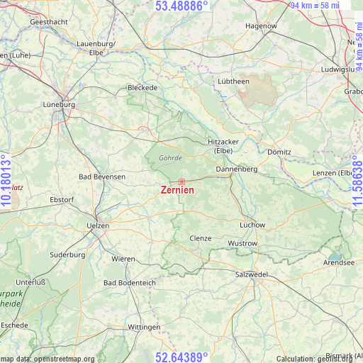
Zernien GPS coordinates[2]
53° 4' 6.42" North, 10° 52' 59.7" East
| Map corner | latitude | longitude |
|---|---|---|
| Upper-left | 53.48886°, | 10.18013° |
| Center: | 53.06845°, | 10.88325° |
| Lower-right: | 52.64389°, | 11.58638° |
| Map W x H: | 94×93.9 km | = 58.4×58.3mi |
| max Lat: | 55.01917° ⇑17.9% North |
| Zernien: | 53.06845° |
| min Lat: | ⇓82.1% South 47.40724° |
| min Long | Zernien | max Long |
| 5.92978° | 10.88325° | 14.98853° |
| W 65.2%⇐ | ⇒34.8% E |
Elevation
Elevation of Zernien is 85 m = 279 ft, and this is 164.1 m = 538 ft below average elevation for this country.
| Max E: |
1256 m = 4121 ft | 71% |
| Avg. | 249.1 m = 817 ft | |
| Zernien | 85 m = 279 ft | |
Min E: |
-5 m = -16 ft | 29% |
See also: Germany elevation on elevation.city.
Geographical zone
Zernien is located in North temperate zone (between Tropic of Cancer and the Arctic Circle). Distance of this North polar circle is 1500.5 km =932.4 mi to North.| Distance of | km | miles | from Zernien |
|---|---|---|---|
| North Pole | 4106.4 | 2551.6 | to North |
| Arctic Circle | 1500.5 | 932.4 | to North |
| Tropic Cancer | 3294.7 | 2047.2 | to South |
| Equator | 5900.7 | 3666.5 | to South |


Nearby cities:
15 places around Zernien: (largest is in red/bold)
• Boitze
12.7 km =7.9 mi,  315°
315°
• Clenze
15.4 km =9.6 mi,  161°
161°
• Dannenberg
14.2 km =8.8 mi,  77°
77°
• Göhrde
9.1 km =5.7 mi,  0°
0°
• Himbergen
10.7 km =6.6 mi,  285°
285°
• Hitzacker
14.2 km =8.8 mi,  48°
48°
• Jameln
13.5 km =8.4 mi,  98°
98°
• Karwitz
9.1 km =5.7 mi, 79°
• Küsten
15.7 km =9.8 mi,  130°
130°
• Nahrendorf
12.6 km =7.8 mi,  338°
338°
• Oetzen
14.9 km =9.3 mi,  248°
248°
• Rosche
12.6 km =7.8 mi,  224°
224°
• Stoetze
6.7 km =4.2 mi,  268°
268°
• Waddeweitz
9.4 km =5.8 mi,  143°
143°
• Weste
12.1 km =7.5 mi, 265°
Sources, notices
• [Note1] Compared only with cities in Germany existing in our database
• [Src1] Map data: © OpenStreetMap contributors (CC-BY-SA)
• [Src2] Other city data from geonames.org with taken over terms of usage.
• [Src3] Geographical zone / Annual Mean Temperature by Robert A. Rohde @ Wikipedia
