Luckau geodata
Luckau (Lower Saxony) is a populated place; located in Germany in Europe/Berlin (GMT+2) time zone. With population of 742 people, there are 8140 cities with bigger population in this country. Compared to other cities in Germany, 81.3% of cities are located further ↓South; 67.7% of cities are located further ←West and 89.3% of cities have higher elevation than Luckau. Note1
Administrative division(s):
- Level 1: Lower Saxony
- Level 3: Landkreis Lüchow-Dannenberg
- Level 4: Luckau (Wendland)


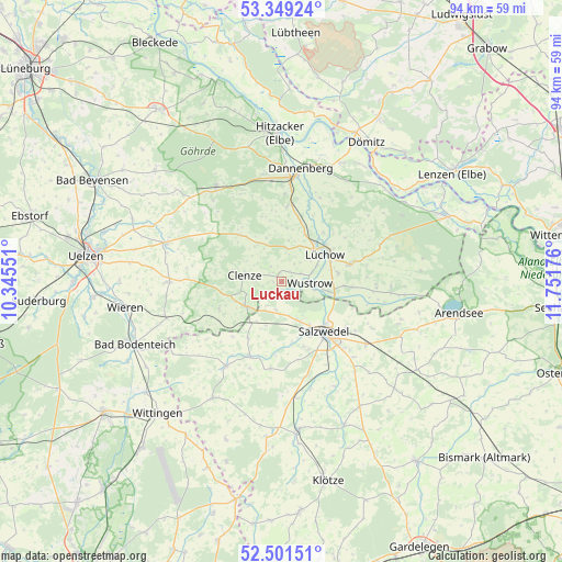
Luckau GPS coordinates[2]
52° 55' 38.82" North, 11° 2' 55.068" East
| Map corner | latitude | longitude |
|---|---|---|
| Upper-left | 53.34924°, | 10.34551° |
| Center: | 52.92745°, | 11.04863° |
| Lower-right: | 52.50151°, | 11.75176° |
| Map W x H: | 94.3×94.3 km | = 58.6×58.6mi |
| max Lat: | 55.01917° ⇑18.7% North |
| Luckau: | 52.92745° |
| min Lat: | ⇓81.3% South 47.40724° |
| min Long | Luckau | max Long |
| 5.92978° | 11.04863° | 14.98853° |
| W 67.7%⇐ | ⇒32.3% E |
Elevation
Elevation of Luckau is 23 m = 75 ft, and this is 226.1 m = 742 ft below average elevation for this country.
| Max E: |
1256 m = 4121 ft | 89.3% |
| Avg. | 249.1 m = 817 ft | |
| Luckau | 23 m = 75 ft | |
Min E: |
-5 m = -16 ft | 10.7% |
See also: Germany elevation on elevation.city.
Geographical zone
Luckau is located in North temperate zone (between Tropic of Cancer and the Arctic Circle). Distance of this North polar circle is 1516.2 km =942.1 mi to North.| Distance of | km | miles | from Luckau |
|---|---|---|---|
| North Pole | 4122.1 | 2561.4 | to North |
| Arctic Circle | 1516.2 | 942.1 | to North |
| Tropic Cancer | 3279.1 | 2037.5 | to South |
| Equator | 5885 | 3656.8 | to South |


Nearby cities:
15 places around Luckau: (largest is in red/bold)
• Bergen an der Dumme
7.4 km =4.6 mi,  236°
236°
• Clenze
6.2 km =3.9 mi,  280°
280°
• Henningen
11 km =6.8 mi,  211°
211°
• Jameln
13.8 km =8.6 mi,  9°
9°
• Kuhfelde
16.7 km =10.4 mi,  164°
164°
• Küsten
5.7 km =3.5 mi, 9°
• Lübbow
9 km =5.6 mi,  101°
101°
• Lüchow
8.4 km =5.2 mi,  57°
57°
• Osterwohle
10.5 km =6.5 mi,  195°
195°
• Salzwedel
10.7 km =6.6 mi,  139°
139°
• Schnega
11.2 km =7 mi,  249°
249°
• Waddeweitz
9.8 km =6.1 mi,  325°
325°
• Wallstawe
14.3 km =8.9 mi,  188°
188°
• Woltersdorf
11.5 km =7.1 mi,  77°
77°
• Wustrow
5.4 km =3.4 mi,  94°
94°
Sources, notices
• [Note1] Compared only with cities in Germany existing in our database
• [Src1] Map data: © OpenStreetMap contributors (CC-BY-SA)
• [Src2] Other city data from geonames.org with taken over terms of usage.
• [Src3] Geographical zone / Annual Mean Temperature by Robert A. Rohde @ Wikipedia
