Ahrbrück geodata
Ahrbrück (Rheinland-Pfalz) is a seat of a fourth-order administrative division; located in Germany in Europe/Berlin (GMT+2) time zone. With population of 1,228 people, there are 6495 cities with bigger population in this country. Compared to other cities in Germany, 53.2% of cities are located further ↑North; 93.5% of cities are located further →East and 53.2% of cities have higher elevation than Ahrbrück. Note1


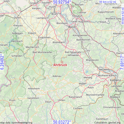
Ahrbrück GPS coordinates[2]
50° 28' 56.1" North, 6° 59' 16.944" East
| Map corner | latitude | longitude |
|---|---|---|
| Upper-left | 50.92754°, | 6.28492° |
| Center: | 50.48225°, | 6.98804° |
| Lower-right: | 50.03272°, | 7.69117° |
| Map W x H: | 99.5×99.5 km | = 61.8×61.8mi |
| max Lat: | 55.01917° ⇑53.2% North |
| Ahrbrück: | 50.48225° |
| min Lat: | ⇓46.8% South 47.40724° |
| min Long | Ahrbrück | max Long |
| 5.92978° | 6.98804° | 14.98853° |
| W 6.5%⇐ | ⇒93.5% E |
Elevation
Elevation of Ahrbrück is 202 m = 663 ft, and this is 47.1 m = 155 ft below average elevation for this country.
| Max E: |
1256 m = 4121 ft | 53.2% |
| Avg. | 249.1 m = 817 ft | |
| Ahrbrück | 202 m = 663 ft | |
Min E: |
-5 m = -16 ft | 46.8% |
See also: Germany elevation on elevation.city.
Geographical zone
Ahrbrück is located in North temperate zone (between Tropic of Cancer and the Arctic Circle). Distance of this North polar circle is 1788.1 km =1111.1 mi to North.| Distance of | km | miles | from Ahrbrück |
|---|---|---|---|
| North Pole | 4394 | 2730.3 | to North |
| Arctic Circle | 1788.1 | 1111.1 | to North |
| Tropic Cancer | 3007.2 | 1868.6 | to South |
| Equator | 5613.1 | 3487.8 | to South |


Nearby cities:
15 places around Ahrbrück: (largest is in red/bold)
• Altenahr
3.9 km =2.4 mi,  4°
4°
• Dernau
7.2 km =4.5 mi,  37°
37°
• Dümpelfeld
6.1 km =3.8 mi,  206°
206°
• Harscheid
7.2 km =4.5 mi,  249°
249°
• Heckenbach
4.7 km =2.9 mi,  111°
111°
• Hönningen
3.2 km =2 mi,  237°
237°
• Insul
7.4 km =4.6 mi,  222°
222°
• Kalenborn
7.6 km =4.7 mi,  6°
6°
• Kesseling
2 km =1.2 mi,  86°
86°
• Kirchsahr
7.7 km =4.8 mi,  305°
305°
• Lind
4.3 km =2.7 mi,  297°
297°
• Mayschoß
4.7 km =2.9 mi,  25°
25°
• Rech
5 km =3.1 mi, 39°
• Schuld
8 km =5 mi, 241°
• Sierscheid
5.7 km =3.5 mi, 240°
Sources, notices
• [Note1] Compared only with cities in Germany existing in our database
• [Src1] Map data: © OpenStreetMap contributors (CC-BY-SA)
• [Src2] Other city data from geonames.org with taken over terms of usage.
• [Src3] Geographical zone / Annual Mean Temperature by Robert A. Rohde @ Wikipedia
