Hochheim geodata
Hochheim (Thuringia) is a populated place; located in Germany in Europe/Berlin (GMT+2) time zone. With population of 530 people, there are 9193 cities with bigger population in this country. Compared to other cities in Germany, 57.3% of cities are located further ↓South; 66.9% of cities are located further ←West and 51.4% of cities have lower elevation than Hochheim. Note1


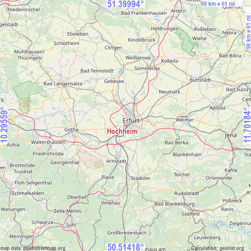
Hochheim GPS coordinates[2]
50° 57' 33.012" North, 10° 59' 55.356" East
| Map corner | latitude | longitude |
|---|---|---|
| Upper-left | 51.39994°, | 10.29559° |
| Center: | 50.95917°, | 10.99871° |
| Lower-right: | 50.51418°, | 11.70184° |
| Map W x H: | 98.5×98.5 km | = 61.2×61.2mi |
| max Lat: | 55.01917° ⇑42.7% North |
| Hochheim: | 50.95917° |
| min Lat: | ⇓57.3% South 47.40724° |
| min Long | Hochheim | max Long |
| 5.92978° | 10.99871° | 14.98853° |
| W 66.9%⇐ | ⇒33.1% E |
Elevation
Elevation of Hochheim is 236 m = 774 ft, and this is 13.1 m = 43 ft below average elevation for this country.
| Max E: |
1256 m = 4121 ft | 48.6% |
| Avg. | 249.1 m = 817 ft | |
| Hochheim | 236 m = 774 ft | |
Min E: |
-5 m = -16 ft | 51.4% |
See also: Germany elevation on elevation.city.
Geographical zone
Hochheim is located in North temperate zone (between Tropic of Cancer and the Arctic Circle). Distance of this North polar circle is 1735 km =1078.1 mi to North.| Distance of | km | miles | from Hochheim |
|---|---|---|---|
| North Pole | 4340.9 | 2697.3 | to North |
| Arctic Circle | 1735 | 1078.1 | to North |
| Tropic Cancer | 3060.2 | 1901.5 | to South |
| Equator | 5666.1 | 3520.8 | to South |


Nearby cities:
15 places around Hochheim: (largest is in red/bold)
• Apfelstädt
10 km =6.2 mi,  230°
230°
• Elxleben
10.7 km =6.6 mi,  341°
341°
• Elxleben
10.9 km =6.8 mi,  160°
160°
• Erfurt
3.2 km =2 mi,  47°
47°
• Gamstädt
8 km =5 mi,  261°
261°
• Ichtershausen
9.5 km =5.9 mi,  192°
192°
• Ingersleben
6 km =3.7 mi, 226°
• Kirchheim
8.5 km =5.3 mi,  171°
171°
• Klettbach
11.6 km =7.2 mi,  114°
114°
• Mönchenholzhausen
10.6 km =6.6 mi,  85°
85°
• Neudietendorf
7.9 km =4.9 mi, 229°
• Nottleben
10.4 km =6.5 mi,  274°
274°
• Rockhausen
7.1 km =4.4 mi, 155°
• Witterda
11.4 km =7.1 mi,  318°
318°
• Zimmernsupra
9.6 km =6 mi,  286°
286°
Sources, notices
• [Note1] Compared only with cities in Germany existing in our database
• [Src1] Map data: © OpenStreetMap contributors (CC-BY-SA)
• [Src2] Other city data from geonames.org with taken over terms of usage.
• [Src3] Geographical zone / Annual Mean Temperature by Robert A. Rohde @ Wikipedia
