Immesheim geodata
Immesheim (Rheinland-Pfalz) is a seat of a fourth-order administrative division; located in Germany in Europe/Berlin (GMT+2) time zone. With population of 150 people, there are 10692 cities with bigger population in this country. Compared to other cities in Germany, 72.8% of cities are located further ↑North; 75.4% of cities are located further →East and 50.1% of cities have lower elevation than Immesheim. Note1


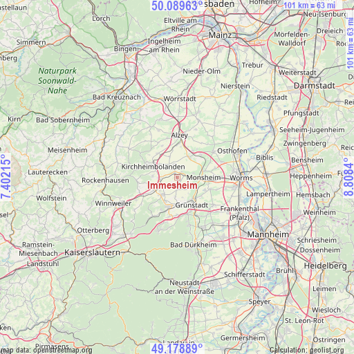
Immesheim GPS coordinates[2]
49° 38' 11.004" North, 8° 6' 19.008" East
| Map corner | latitude | longitude |
|---|---|---|
| Upper-left | 50.08963°, | 7.40215° |
| Center: | 49.63639°, | 8.10528° |
| Lower-right: | 49.17889°, | 8.8084° |
| Map W x H: | 101.3×101.3 km | = 62.9×62.9mi |
| max Lat: | 55.01917° ⇑72.8% North |
| Immesheim: | 49.63639° |
| min Lat: | ⇓27.2% South 47.40724° |
| min Long | Immesheim | max Long |
| 5.92978° | 8.10528° | 14.98853° |
| W 24.6%⇐ | ⇒75.4% E |
Elevation
Elevation of Immesheim is 226 m = 741 ft, and this is 23.1 m = 76 ft below average elevation for this country.
| Max E: |
1256 m = 4121 ft | 49.9% |
| Avg. | 249.1 m = 817 ft | |
| Immesheim | 226 m = 741 ft | |
Min E: |
-5 m = -16 ft | 50.1% |
See also: Germany elevation on elevation.city.
Geographical zone
Immesheim is located in North temperate zone (between Tropic of Cancer and the Arctic Circle). Distance of this North polar circle is 1882.1 km =1169.5 mi to North.| Distance of | km | miles | from Immesheim |
|---|---|---|---|
| North Pole | 4488 | 2788.7 | to North |
| Arctic Circle | 1882.1 | 1169.5 | to North |
| Tropic Cancer | 2913.1 | 1810.1 | to South |
| Equator | 5519 | 3429.3 | to South |


Nearby cities:
15 places around Immesheim: (largest is in red/bold)
• Albisheim
1.6 km =1 mi,  331°
331°
• Biedesheim
3.5 km =2.2 mi,  177°
177°
• Bubenheim
1.3 km =0.8 mi,  135°
135°
• Einselthum
2.2 km =1.4 mi,  39°
39°
• Gauersheim
3.5 km =2.2 mi,  317°
317°
• Kindenheim
5.1 km =3.2 mi,  123°
123°
• Lautersheim
5.5 km =3.4 mi,  185°
185°
• Marnheim
4.7 km =2.9 mi,  265°
265°
• Mölsheim
4.8 km =3 mi,  76°
76°
• Ottersheim
1.2 km =0.7 mi,  168°
168°
• Quirnheim
6 km =3.7 mi, 165°
• Rittersheim
4.6 km =2.9 mi,  312°
312°
• Rüssingen
2.6 km =1.6 mi,  208°
208°
• Stetten
3.8 km =2.4 mi,  345°
345°
• Wachenheim
4.3 km =2.7 mi,  88°
88°
Sources, notices
• [Note1] Compared only with cities in Germany existing in our database
• [Src1] Map data: © OpenStreetMap contributors (CC-BY-SA)
• [Src2] Other city data from geonames.org with taken over terms of usage.
• [Src3] Geographical zone / Annual Mean Temperature by Robert A. Rohde @ Wikipedia
