Hundsangen geodata
Hundsangen (Rheinland-Pfalz) is a seat of a fourth-order administrative division; located in Germany in Europe/Berlin (GMT+2) time zone. With population of 2,103 people, there are 4924 cities with bigger population in this country. Compared to other cities in Germany, 53.8% of cities are located further ↑North; 77.5% of cities are located further →East and 55.7% of cities have lower elevation than Hundsangen. Note1


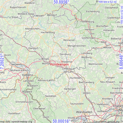
Hundsangen GPS coordinates[2]
50° 27' 0" North, 7° 58' 59.988" East
| Map corner | latitude | longitude |
|---|---|---|
| Upper-left | 50.8956°, | 7.28021° |
| Center: | 50.45°, | 7.98333° |
| Lower-right: | 50.00016°, | 8.68646° |
| Map W x H: | 99.6×99.6 km | = 61.9×61.9mi |
| max Lat: | 55.01917° ⇑53.8% North |
| Hundsangen: | 50.45° |
| min Lat: | ⇓46.2% South 47.40724° |
| min Long | Hundsangen | max Long |
| 5.92978° | 7.98333° | 14.98853° |
| W 22.5%⇐ | ⇒77.5% E |
Elevation
Elevation of Hundsangen is 263 m = 863 ft, and this is 13.9 m = 46 ft above average elevation for this country.
| Max E: |
1256 m = 4121 ft | 44.3% |
| Hundsangen | 263 m 863 ft | |
| Avg. | 249.1 m = 817 ft | |
Min E: |
-5 m = -16 ft | 55.7% |
See also: Germany elevation on elevation.city.
Geographical zone
Hundsangen is located in North temperate zone (between Tropic of Cancer and the Arctic Circle). Distance of this North polar circle is 1791.7 km =1113.3 mi to North.| Distance of | km | miles | from Hundsangen |
|---|---|---|---|
| North Pole | 4397.5 | 2732.5 | to North |
| Arctic Circle | 1791.7 | 1113.3 | to North |
| Tropic Cancer | 3003.6 | 1866.3 | to South |
| Equator | 5609.5 | 3485.6 | to South |


Nearby cities:
15 places around Hundsangen: (largest is in red/bold)
• Berod bei Wallmerod
5.1 km =3.2 mi,  316°
316°
• Dreikirchen
3 km =1.9 mi,  231°
231°
• Elz
5.1 km =3.2 mi,  136°
136°
• Girod
4.7 km =2.9 mi,  270°
270°
• Görgeshausen
4.4 km =2.7 mi,  212°
212°
• Hadamar
4.2 km =2.6 mi,  96°
96°
• Molsberg
3.7 km =2.3 mi,  0°
0°
• Nentershausen
5.1 km =3.2 mi,  223°
223°
• Niedererbach
2.7 km =1.7 mi,  193°
193°
• Nomborn
5.1 km =3.2 mi,  248°
248°
• Obererbach
1.2 km =0.7 mi, 270°
• Steinefrenz
3.7 km =2.3 mi,  286°
286°
• Wallmerod
4.4 km =2.7 mi,  327°
327°
• Weroth
2.7 km =1.7 mi,  295°
295°
• Zehnhausen bei Wallmerod
5.1 km =3.2 mi, 304°
Sources, notices
• [Note1] Compared only with cities in Germany existing in our database
• [Src1] Map data: © OpenStreetMap contributors (CC-BY-SA)
• [Src2] Other city data from geonames.org with taken over terms of usage.
• [Src3] Geographical zone / Annual Mean Temperature by Robert A. Rohde @ Wikipedia
