Hadamar geodata
Hadamar (Hesse) is a populated place; located in Germany in Europe/Berlin (GMT+2) time zone. With population of 12,131 people, there are 1349 cities with bigger population in this country. Compared to other cities in Germany, 53.8% of cities are located further ↑North; 76.4% of cities are located further →East and 62.7% of cities have higher elevation than Hadamar. Note1
Administrative division(s):
- Level 1: Hesse
- Level 2: Regierungsbezirk Gießen
- Level 3: Landkreis Limburg-Weilburg
- Level 4: Hadamar


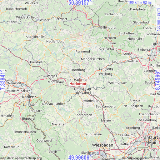
Hadamar GPS coordinates[2]
50° 26' 45.348" North, 8° 2' 33.108" East
| Map corner | latitude | longitude |
|---|---|---|
| Upper-left | 50.89157°, | 7.33941° |
| Center: | 50.44593°, | 8.04253° |
| Lower-right: | 49.99606°, | 8.74566° |
| Map W x H: | 99.6×99.6 km | = 61.9×61.9mi |
| max Lat: | 55.01917° ⇑53.8% North |
| Hadamar: | 50.44593° |
| min Lat: | ⇓46.2% South 47.40724° |
| min Long | Hadamar | max Long |
| 5.92978° | 8.04253° | 14.98853° |
| W 23.6%⇐ | ⇒76.4% E |
Elevation
Elevation of Hadamar is 134 m = 440 ft, and this is 115.1 m = 378 ft below average elevation for this country.
| Max E: |
1256 m = 4121 ft | 62.7% |
| Avg. | 249.1 m = 817 ft | |
| Hadamar | 134 m = 440 ft | |
Min E: |
-5 m = -16 ft | 37.3% |
See also: Germany elevation on elevation.city.
Geographical zone
Hadamar is located in North temperate zone (between Tropic of Cancer and the Arctic Circle). Distance of this North polar circle is 1792.1 km =1113.6 mi to North.| Distance of | km | miles | from Hadamar |
|---|---|---|---|
| North Pole | 4398 | 2732.8 | to North |
| Arctic Circle | 1792.1 | 1113.6 | to North |
| Tropic Cancer | 3003.1 | 1866 | to South |
| Equator | 5609.1 | 3485.3 | to South |


Nearby cities:
15 places around Hadamar: (largest is in red/bold)
• Aull
7.3 km =4.5 mi,  203°
203°
• Dehrn
4.9 km =3 mi,  125°
125°
• Dreikirchen
6.7 km =4.2 mi,  257°
257°
• Elz
3.3 km =2.1 mi,  191°
191°
• Görgeshausen
7.3 km =4.5 mi,  243°
243°
• Gückingen
6.6 km =4.1 mi, 202°
• Hambach
6.6 km =4.1 mi,  219°
219°
• Hundsangen
4.2 km =2.6 mi,  276°
276°
• Limburg an der Lahn
7 km =4.3 mi,  175°
175°
• Molsberg
5.9 km =3.7 mi,  314°
314°
• Niedererbach
5.3 km =3.3 mi,  245°
245°
• Obererbach
5.4 km =3.4 mi,  274°
274°
• Steeden
6.9 km =4.3 mi,  119°
119°
• Wallmerod
7.8 km =4.8 mi,  302°
302°
• Weroth
6.9 km =4.3 mi, 283°
Sources, notices
• [Note1] Compared only with cities in Germany existing in our database
• [Src1] Map data: © OpenStreetMap contributors (CC-BY-SA)
• [Src2] Other city data from geonames.org with taken over terms of usage.
• [Src3] Geographical zone / Annual Mean Temperature by Robert A. Rohde @ Wikipedia
