Elz geodata
Elz (Hesse) is a seat of a fourth-order administrative division; located in Germany in Europe/Berlin (GMT+2) time zone. With population of 7,972 people, there are 1961 cities with bigger population in this country. Compared to other cities in Germany, 54.4% of cities are located further ↑North; 76.6% of cities are located further →East and 59.2% of cities have higher elevation than Elz. Note1
Administrative division(s):
- Level 1: Hesse
- Level 2: Regierungsbezirk Gießen
- Level 3: Landkreis Limburg-Weilburg
- Level 4: Elz


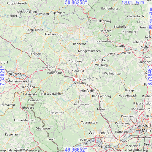
Elz GPS coordinates[2]
50° 25' 0.012" North, 8° 1' 59.988" East
| Map corner | latitude | longitude |
|---|---|---|
| Upper-left | 50.86258°, | 7.33021° |
| Center: | 50.41667°, | 8.03333° |
| Lower-right: | 49.96652°, | 8.73646° |
| Map W x H: | 99.6×99.6 km | = 61.9×61.9mi |
| max Lat: | 55.01917° ⇑54.4% North |
| Elz: | 50.41667° |
| min Lat: | ⇓45.6% South 47.40724° |
| min Long | Elz | max Long |
| 5.92978° | 8.03333° | 14.98853° |
| W 23.4%⇐ | ⇒76.6% E |
Elevation
Elevation of Elz is 159 m = 522 ft, and this is 90.1 m = 296 ft below average elevation for this country.
| Max E: |
1256 m = 4121 ft | 59.2% |
| Avg. | 249.1 m = 817 ft | |
| Elz | 159 m = 522 ft | |
Min E: |
-5 m = -16 ft | 40.8% |
See also: Germany elevation on elevation.city.
Geographical zone
Elz is located in North temperate zone (between Tropic of Cancer and the Arctic Circle). Distance of this North polar circle is 1795.4 km =1115.6 mi to North.| Distance of | km | miles | from Elz |
|---|---|---|---|
| North Pole | 4401.3 | 2734.8 | to North |
| Arctic Circle | 1795.4 | 1115.6 | to North |
| Tropic Cancer | 2999.9 | 1864.1 | to South |
| Equator | 5605.8 | 3483.3 | to South |


Nearby cities:
15 places around Elz: (largest is in red/bold)
• Altendiez
6.6 km =4.1 mi,  212°
212°
• Aull
4.1 km =2.5 mi, 212°
• Dehrn
4.6 km =2.9 mi,  84°
84°
• Diez
5.1 km =3.2 mi,  201°
201°
• Dreikirchen
6.2 km =3.9 mi,  287°
287°
• Görgeshausen
5.9 km =3.7 mi,  270°
270°
• Gückingen
3.4 km =2.1 mi, 212°
• Hadamar
3.3 km =2.1 mi,  11°
11°
• Hambach
4 km =2.5 mi,  242°
242°
• Heistenbach
5.3 km =3.3 mi,  218°
218°
• Hundsangen
5.1 km =3.2 mi,  316°
316°
• Limburg an der Lahn
3.9 km =2.4 mi,  161°
161°
• Niedererbach
4.3 km =2.7 mi,  284°
284°
• Obererbach
6 km =3.7 mi,  308°
308°
• Steeden
6.7 km =4.2 mi,  91°
91°
Sources, notices
• [Note1] Compared only with cities in Germany existing in our database
• [Src1] Map data: © OpenStreetMap contributors (CC-BY-SA)
• [Src2] Other city data from geonames.org with taken over terms of usage.
• [Src3] Geographical zone / Annual Mean Temperature by Robert A. Rohde @ Wikipedia
