Huje geodata
Huje (Schleswig-Holstein) is a seat of a fourth-order administrative division; located in Germany in Europe/Berlin (GMT+2) time zone. With population of 297 people, there are 10065 cities with bigger population in this country. Compared to other cities in Germany, 92.4% of cities are located further ↓South; 58.8% of cities are located further →East and 94.8% of cities have higher elevation than Huje. Note1


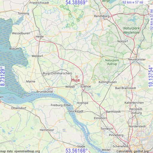
Huje GPS coordinates[2]
53° 58' 38.028" North, 9° 26' 3.876" East
| Map corner | latitude | longitude |
|---|---|---|
| Upper-left | 54.38869°, | 8.73129° |
| Center: | 53.97723°, | 9.43441° |
| Lower-right: | 53.56166°, | 10.13754° |
| Map W x H: | 92×92 km | = 57.2×57.2mi |
| max Lat: | 55.01917° ⇑7.6% North |
| Huje: | 53.97723° |
| min Lat: | ⇓92.4% South 47.40724° |
| min Long | Huje | max Long |
| 5.92978° | 9.43441° | 14.98853° |
| W 41.2%⇐ | ⇒58.8% E |
Elevation
Elevation of Huje is 9 m = 30 ft, and this is 240.1 m = 788 ft below average elevation for this country.
| Max E: |
1256 m = 4121 ft | 94.8% |
| Avg. | 249.1 m = 817 ft | |
| Huje | 9 m = 30 ft | |
Min E: |
-5 m = -16 ft | 5.2% |
See also: Germany elevation on elevation.city.
Geographical zone
Huje is located in North temperate zone (between Tropic of Cancer and the Arctic Circle). Distance of this North polar circle is 1399.5 km =869.6 mi to North.| Distance of | km | miles | from Huje |
|---|---|---|---|
| North Pole | 4005.4 | 2488.8 | to North |
| Arctic Circle | 1399.5 | 869.6 | to North |
| Tropic Cancer | 3395.8 | 2110.1 | to South |
| Equator | 6001.7 | 3729.3 | to South |


Nearby cities:
15 places around Huje: (largest is in red/bold)
• Agethorst
4.7 km =2.9 mi,  1°
1°
• Bekdorf
4.3 km =2.7 mi,  190°
190°
• Bekmünde
5.9 km =3.7 mi,  172°
172°
• Heiligenstedten
5.6 km =3.5 mi,  152°
152°
• Kaaks
2.7 km =1.7 mi,  58°
58°
• Kaisborstel
5.1 km =3.2 mi,  37°
37°
• Kleve
2.5 km =1.6 mi,  242°
242°
• Krummendiek
3.6 km =2.2 mi,  198°
198°
• Mehlbek
3 km =1.9 mi, 0°
• Moorhusen
3.9 km =2.4 mi, 238°
• Nienbüttel
6 km =3.7 mi,  347°
347°
• Nutteln
3.3 km =2.1 mi,  290°
290°
• Oldendorf
3.1 km =1.9 mi, 149°
• Ottenbüttel
4.6 km =2.9 mi,  98°
98°
• Vaale
4.2 km =2.6 mi,  307°
307°
Sources, notices
• [Note1] Compared only with cities in Germany existing in our database
• [Src1] Map data: © OpenStreetMap contributors (CC-BY-SA)
• [Src2] Other city data from geonames.org with taken over terms of usage.
• [Src3] Geographical zone / Annual Mean Temperature by Robert A. Rohde @ Wikipedia
