Hüffenhardt geodata
Hüffenhardt (Baden-Württemberg) is a seat of a fourth-order administrative division; located in Germany in Europe/Berlin (GMT+2) time zone. With population of 2,080 people, there are 4959 cities with bigger population in this country. Compared to other cities in Germany, 78.8% of cities are located further ↑North; 64.3% of cities are located further →East and 62.2% of cities have lower elevation than Hüffenhardt. Note1
Administrative division(s):
- Level 1: Baden-Württemberg
- Level 2: Karlsruhe Region
- Level 3: Neckar-Odenwald-Kreis
- Level 4: Hüffenhardt


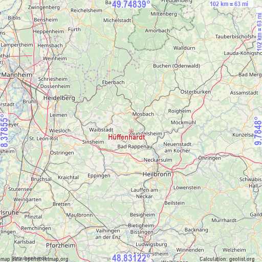
Hüffenhardt GPS coordinates[2]
49° 17' 30.984" North, 9° 4' 54.012" East
| Map corner | latitude | longitude |
|---|---|---|
| Upper-left | 49.74839°, | 8.37855° |
| Center: | 49.29194°, | 9.08167° |
| Lower-right: | 48.83122°, | 9.7848° |
| Map W x H: | 102×102 km | = 63.4×63.4mi |
| max Lat: | 55.01917° ⇑78.8% North |
| Hüffenhardt: | 49.29194° |
| min Lat: | ⇓21.2% South 47.40724° |
| min Long | Hüffenhardt | max Long |
| 5.92978° | 9.08167° | 14.98853° |
| W 35.7%⇐ | ⇒64.3% E |
Elevation
Elevation of Hüffenhardt is 303 m = 994 ft, and this is 53.9 m = 177 ft above average elevation for this country.
| Max E: |
1256 m = 4121 ft | 37.8% |
| Hüffenhardt | 303 m 994 ft | |
| Avg. | 249.1 m = 817 ft | |
Min E: |
-5 m = -16 ft | 62.2% |
See also: Germany elevation on elevation.city.
Geographical zone
Hüffenhardt is located in North temperate zone (between Tropic of Cancer and the Arctic Circle). Distance of this North polar circle is 1920.4 km =1193.3 mi to North.| Distance of | km | miles | from Hüffenhardt |
|---|---|---|---|
| North Pole | 4526.3 | 2812.5 | to North |
| Arctic Circle | 1920.4 | 1193.3 | to North |
| Tropic Cancer | 2874.8 | 1786.3 | to South |
| Equator | 5480.7 | 3405.5 | to South |


Nearby cities:
15 places around Hüffenhardt: (largest is in red/bold)
• Aglasterhausen
10 km =6.2 mi,  316°
316°
• Bad Rappenau
6.1 km =3.8 mi,  166°
166°
• Bad Wimpfen
8.8 km =5.5 mi,  141°
141°
• Binau
8.7 km =5.4 mi,  348°
348°
• Gundelsheim
5.8 km =3.6 mi,  99°
99°
• Haßmersheim
5 km =3.1 mi,  79°
79°
• Helmstadt-Bargen
6.6 km =4.1 mi,  292°
292°
• Kirchardt
11.7 km =7.3 mi,  214°
214°
• Mosbach
8.5 km =5.3 mi,  36°
36°
• Neckarbischofsheim
8.6 km =5.3 mi,  273°
273°
• Neckarzimmern
4.8 km =3 mi,  50°
50°
• Neunkirchen
11.8 km =7.3 mi,  334°
334°
• Obrigheim
6.7 km =4.2 mi,  5°
5°
• Offenau
7.7 km =4.8 mi,  131°
131°
• Siegelsbach
2.5 km =1.6 mi, 166°
Sources, notices
• [Note1] Compared only with cities in Germany existing in our database
• [Src1] Map data: © OpenStreetMap contributors (CC-BY-SA)
• [Src2] Other city data from geonames.org with taken over terms of usage.
• [Src3] Geographical zone / Annual Mean Temperature by Robert A. Rohde @ Wikipedia
