Mosbach geodata
Mosbach (Baden-Württemberg) is a seat of a third-order administrative division; located in Germany in Europe/Berlin (GMT+2) time zone. With population of 25,106 people, there are 584 cities with bigger population in this country. Compared to other cities in Germany, 77.8% of cities are located further ↑North; 63.1% of cities are located further →East and 55.4% of cities have higher elevation than Mosbach. Note1
Administrative division(s):
- Level 1: Baden-Württemberg
- Level 2: Karlsruhe Region
- Level 3: Neckar-Odenwald-Kreis
- Level 4: Mosbach


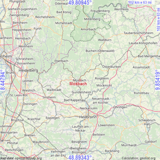
Mosbach GPS coordinates[2]
49° 21' 12.852" North, 9° 9' 3.816" East
| Map corner | latitude | longitude |
|---|---|---|
| Upper-left | 49.80945°, | 8.44794° |
| Center: | 49.35357°, | 9.15106° |
| Lower-right: | 48.89343°, | 9.85419° |
| Map W x H: | 101.9×101.8 km | = 63.3×63.3mi |
| max Lat: | 55.01917° ⇑77.8% North |
| Mosbach: | 49.35357° |
| min Lat: | ⇓22.2% South 47.40724° |
| min Long | Mosbach | max Long |
| 5.92978° | 9.15106° | 14.98853° |
| W 36.9%⇐ | ⇒63.1% E |
Elevation
Elevation of Mosbach is 186 m = 610 ft, and this is 63.1 m = 207 ft below average elevation for this country.
| Max E: |
1256 m = 4121 ft | 55.4% |
| Avg. | 249.1 m = 817 ft | |
| Mosbach | 186 m = 610 ft | |
Min E: |
-5 m = -16 ft | 44.6% |
See also: Germany elevation on elevation.city.
Geographical zone
Mosbach is located in North temperate zone (between Tropic of Cancer and the Arctic Circle). Distance of this North polar circle is 1913.6 km =1189.1 mi to North.| Distance of | km | miles | from Mosbach |
|---|---|---|---|
| North Pole | 4519.5 | 2808.3 | to North |
| Arctic Circle | 1913.6 | 1189.1 | to North |
| Tropic Cancer | 2881.7 | 1790.6 | to South |
| Equator | 5487.6 | 3409.8 | to South |


Nearby cities:
15 places around Mosbach: (largest is in red/bold)
• Aglasterhausen
11.9 km =7.4 mi,  271°
271°
• Billigheim
7.5 km =4.7 mi,  94°
94°
• Binau
6.9 km =4.3 mi,  283°
283°
• Fahrenbach
8.7 km =5.4 mi,  359°
359°
• Gundelsheim
7.8 km =4.8 mi,  175°
175°
• Haßmersheim
6 km =3.7 mi, 180°
• Hüffenhardt
8.5 km =5.3 mi,  216°
216°
• Neckargerach
8 km =5 mi,  310°
310°
• Neckarzimmern
4 km =2.5 mi,  199°
199°
• Neudenau
11 km =6.8 mi,  128°
128°
• Neunkirchen
10.8 km =6.7 mi,  290°
290°
• Obrigheim
4.4 km =2.7 mi, 267°
• Offenau
12 km =7.5 mi, 176°
• Siegelsbach
10.3 km =6.4 mi,  205°
205°
• Zwingenberg
10.8 km =6.7 mi, 312°
Sources, notices
• [Note1] Compared only with cities in Germany existing in our database
• [Src1] Map data: © OpenStreetMap contributors (CC-BY-SA)
• [Src2] Other city data from geonames.org with taken over terms of usage.
• [Src3] Geographical zone / Annual Mean Temperature by Robert A. Rohde @ Wikipedia
