Offenau geodata
Offenau (Baden-Württemberg) is a seat of a fourth-order administrative division; located in Germany in Europe/Berlin (GMT+2) time zone. With population of 2,748 people, there are 4197 cities with bigger population in this country. Compared to other cities in Germany, 79.7% of cities are located further ↑North; 63% of cities are located further →East and 60.3% of cities have higher elevation than Offenau. Note1
Administrative division(s):
- Level 1: Baden-Württemberg
- Level 2: Regierungsbezirk Stuttgart
- Level 3: Landkreis Heilbronn
- Level 4: Offenau


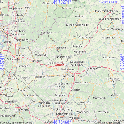
Offenau GPS coordinates[2]
49° 14' 44.988" North, 9° 9' 38.016" East
| Map corner | latitude | longitude |
|---|---|---|
| Upper-left | 49.70271°, | 8.45743° |
| Center: | 49.24583°, | 9.16056° |
| Lower-right: | 48.78468°, | 9.86368° |
| Map W x H: | 102.1×102.1 km | = 63.4×63.4mi |
| max Lat: | 55.01917° ⇑79.7% North |
| Offenau: | 49.24583° |
| min Lat: | ⇓20.3% South 47.40724° |
| min Long | Offenau | max Long |
| 5.92978° | 9.16056° | 14.98853° |
| W 37%⇐ | ⇒63% E |
Elevation
Elevation of Offenau is 150 m = 492 ft, and this is 99.1 m = 325 ft below average elevation for this country.
| Max E: |
1256 m = 4121 ft | 60.3% |
| Avg. | 249.1 m = 817 ft | |
| Offenau | 150 m = 492 ft | |
Min E: |
-5 m = -16 ft | 39.7% |
See also: Germany elevation on elevation.city.
Geographical zone
Offenau is located in North temperate zone (between Tropic of Cancer and the Arctic Circle). Distance of this North polar circle is 1925.6 km =1196.5 mi to North.| Distance of | km | miles | from Offenau |
|---|---|---|---|
| North Pole | 4531.4 | 2815.7 | to North |
| Arctic Circle | 1925.6 | 1196.5 | to North |
| Tropic Cancer | 2869.7 | 1783.1 | to South |
| Equator | 5475.6 | 3402.4 | to South |


Nearby cities:
15 places around Offenau: (largest is in red/bold)
• Bad Rappenau
4.3 km =2.7 mi,  259°
259°
• Bad Wimpfen
1.8 km =1.1 mi,  189°
189°
• Erlenbach
11.3 km =7 mi,  136°
136°
• Gundelsheim
4.2 km =2.6 mi,  359°
359°
• Haßmersheim
6.1 km =3.8 mi,  352°
352°
• Hüffenhardt
7.7 km =4.8 mi,  311°
311°
• Leingarten
11.5 km =7.1 mi,  195°
195°
• Massenbachhausen
11.4 km =7.1 mi,  228°
228°
• Mosbach
12 km =7.5 mi, 356°
• Neckarsulm
7.9 km =4.9 mi, 143°
• Neckarzimmern
8.4 km =5.2 mi, 346°
• Neudenau
9.4 km =5.8 mi,  57°
57°
• Oedheim
6.8 km =4.2 mi,  95°
95°
• Siegelsbach
5.8 km =3.6 mi,  297°
297°
• Untereisesheim
4.9 km =3 mi, 142°
Sources, notices
• [Note1] Compared only with cities in Germany existing in our database
• [Src1] Map data: © OpenStreetMap contributors (CC-BY-SA)
• [Src2] Other city data from geonames.org with taken over terms of usage.
• [Src3] Geographical zone / Annual Mean Temperature by Robert A. Rohde @ Wikipedia
