Hornburg geodata
Hornburg (Lower Saxony) is a populated place; located in Germany in Europe/Berlin (GMT+2) time zone. With population of 2,689 people, there are 4242 cities with bigger population in this country. Compared to other cities in Germany, 72.3% of cities are located further ↓South; 60.9% of cities are located further ←West and 69.8% of cities have higher elevation than Hornburg. Note1
Administrative division(s):
- Level 1: Lower Saxony
- Level 3: Landkreis Wolfenbüttel
- Level 4: Schladen-Werla


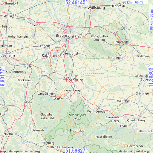
Hornburg GPS coordinates[2]
52° 1' 51.42" North, 10° 36' 17.64" East
| Map corner | latitude | longitude |
|---|---|---|
| Upper-left | 52.46145°, | 9.90177° |
| Center: | 52.03095°, | 10.6049° |
| Lower-right: | 51.59627°, | 11.30803° |
| Map W x H: | 96.2×96.2 km | = 59.8×59.8mi |
| max Lat: | 55.01917° ⇑27.7% North |
| Hornburg: | 52.03095° |
| min Lat: | ⇓72.3% South 47.40724° |
| min Long | Hornburg | max Long |
| 5.92978° | 10.6049° | 14.98853° |
| W 60.9%⇐ | ⇒39.1% E |
Elevation
Elevation of Hornburg is 92 m = 302 ft, and this is 157.1 m = 515 ft below average elevation for this country.
| Max E: |
1256 m = 4121 ft | 69.8% |
| Avg. | 249.1 m = 817 ft | |
| Hornburg | 92 m = 302 ft | |
Min E: |
-5 m = -16 ft | 30.2% |
See also: Germany elevation on elevation.city.
Geographical zone
Hornburg is located in North temperate zone (between Tropic of Cancer and the Arctic Circle). Distance of this North polar circle is 1615.9 km =1004.1 mi to North.| Distance of | km | miles | from Hornburg |
|---|---|---|---|
| North Pole | 4221.8 | 2623.3 | to North |
| Arctic Circle | 1615.9 | 1004.1 | to North |
| Tropic Cancer | 3179.4 | 1975.6 | to South |
| Equator | 5785.3 | 3594.8 | to South |


Nearby cities:
15 places around Hornburg: (largest is in red/bold)
• Achim
3.2 km =2 mi,  7°
7°
• Börßum
4.5 km =2.8 mi,  341°
341°
• Dorstadt
8.1 km =5 mi, 341°
• Gielde
7.6 km =4.7 mi,  274°
274°
• Hedeper
6.7 km =4.2 mi,  53°
53°
• Heiningen
5.5 km =3.4 mi,  321°
321°
• Kissenbrück
8.8 km =5.5 mi,  353°
353°
• Lüttgenrode
8.2 km =5.1 mi,  149°
149°
• Osterwieck
9.9 km =6.2 mi,  133°
133°
• Roklum
10.1 km =6.3 mi,  66°
66°
• Schladen
4.6 km =2.9 mi,  257°
257°
• Semmenstedt
9.4 km =5.8 mi,  42°
42°
• Vienenburg
9.2 km =5.7 mi,  197°
197°
• Werlaburgdorf
5.1 km =3.2 mi,  294°
294°
• Wülperode
5.5 km =3.4 mi,  184°
184°
Sources, notices
• [Note1] Compared only with cities in Germany existing in our database
• [Src1] Map data: © OpenStreetMap contributors (CC-BY-SA)
• [Src2] Other city data from geonames.org with taken over terms of usage.
• [Src3] Geographical zone / Annual Mean Temperature by Robert A. Rohde @ Wikipedia
