Hedeper geodata
Hedeper (Lower Saxony) is a seat of a fourth-order administrative division; located in Germany in Europe/Berlin (GMT+2) time zone. With population of 588 people, there are 8883 cities with bigger population in this country. Compared to other cities in Germany, 72.7% of cities are located further ↓South; 62.2% of cities are located further ←West and 65.8% of cities have higher elevation than Hedeper. Note1


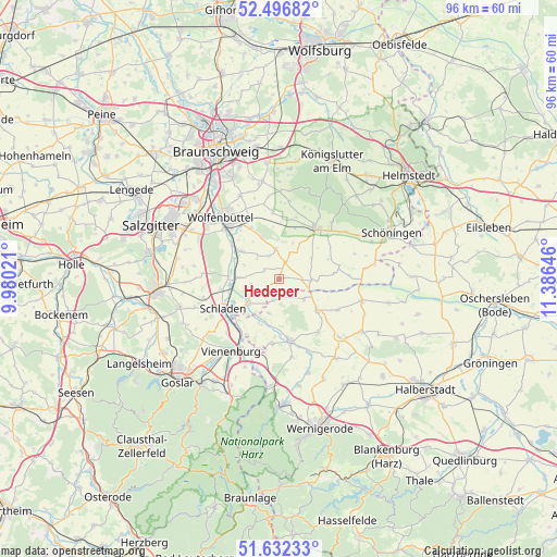
Hedeper GPS coordinates[2]
52° 4' 0.012" North, 10° 40' 59.988" East
| Map corner | latitude | longitude |
|---|---|---|
| Upper-left | 52.49682°, | 9.98021° |
| Center: | 52.06667°, | 10.68333° |
| Lower-right: | 51.63233°, | 11.38646° |
| Map W x H: | 96.1×96.1 km | = 59.7×59.7mi |
| max Lat: | 55.01917° ⇑27.3% North |
| Hedeper: | 52.06667° |
| min Lat: | ⇓72.7% South 47.40724° |
| min Long | Hedeper | max Long |
| 5.92978° | 10.68333° | 14.98853° |
| W 62.2%⇐ | ⇒37.8% E |
Elevation
Elevation of Hedeper is 115 m = 377 ft, and this is 134.1 m = 440 ft below average elevation for this country.
| Max E: |
1256 m = 4121 ft | 65.8% |
| Avg. | 249.1 m = 817 ft | |
| Hedeper | 115 m = 377 ft | |
Min E: |
-5 m = -16 ft | 34.2% |
See also: Germany elevation on elevation.city.
Geographical zone
Hedeper is located in North temperate zone (between Tropic of Cancer and the Arctic Circle). Distance of this North polar circle is 1611.9 km =1001.6 mi to North.| Distance of | km | miles | from Hedeper |
|---|---|---|---|
| North Pole | 4217.8 | 2620.8 | to North |
| Arctic Circle | 1611.9 | 1001.6 | to North |
| Tropic Cancer | 3183.4 | 1978.1 | to South |
| Equator | 5789.3 | 3597.3 | to South |


Nearby cities:
15 places around Hedeper: (largest is in red/bold)
• Achim
5 km =3.1 mi,  260°
260°
• Börßum
6.8 km =4.2 mi,  272°
272°
• Dorstadt
8.8 km =5.5 mi,  294°
294°
• Gevensleben
9.6 km =6 mi,  83°
83°
• Heiningen
8.8 km =5.5 mi, 271°
• Hornburg
6.7 km =4.2 mi,  233°
233°
• Kissenbrück
8 km =5 mi,  306°
306°
• Remlingen
5.3 km =3.3 mi,  353°
353°
• Roklum
3.9 km =2.4 mi,  90°
90°
• Semmenstedt
3.2 km =2 mi,  17°
17°
• Uehrde
6.7 km =4.2 mi,  57°
57°
• Vahlberg
7.8 km =4.8 mi, 17°
• Werlaburgdorf
10.2 km =6.3 mi, 259°
• Winnigstedt
5.8 km =3.6 mi, 90°
• Wittmar
7.6 km =4.7 mi,  337°
337°
Sources, notices
• [Note1] Compared only with cities in Germany existing in our database
• [Src1] Map data: © OpenStreetMap contributors (CC-BY-SA)
• [Src2] Other city data from geonames.org with taken over terms of usage.
• [Src3] Geographical zone / Annual Mean Temperature by Robert A. Rohde @ Wikipedia
