Vienenburg geodata
Vienenburg (Lower Saxony) is a populated place; located in Germany in Europe/Berlin (GMT+2) time zone. With population of 11,417 people, there are 1446 cities with bigger population in this country. Compared to other cities in Germany, 71.7% of cities are located further ↓South; 60.1% of cities are located further ←West and 61.8% of cities have higher elevation than Vienenburg. Note1


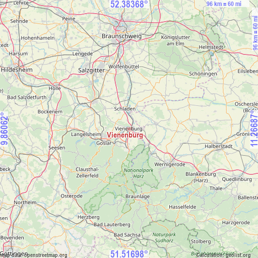
Vienenburg GPS coordinates[2]
51° 57' 8.712" North, 10° 33' 49.464" East
| Map corner | latitude | longitude |
|---|---|---|
| Upper-left | 52.38368°, | 9.86062° |
| Center: | 51.95242°, | 10.56374° |
| Lower-right: | 51.51698°, | 11.26687° |
| Map W x H: | 96.4×96.4 km | = 59.9×59.9mi |
| max Lat: | 55.01917° ⇑28.3% North |
| Vienenburg: | 51.95242° |
| min Lat: | ⇓71.7% South 47.40724° |
| min Long | Vienenburg | max Long |
| 5.92978° | 10.56374° | 14.98853° |
| W 60.1%⇐ | ⇒39.9% E |
Elevation
Elevation of Vienenburg is 140 m = 459 ft, and this is 109.1 m = 358 ft below average elevation for this country.
| Max E: |
1256 m = 4121 ft | 61.8% |
| Avg. | 249.1 m = 817 ft | |
| Vienenburg | 140 m = 459 ft | |
Min E: |
-5 m = -16 ft | 38.2% |
See also: Germany elevation on elevation.city.
Geographical zone
Vienenburg is located in North temperate zone (between Tropic of Cancer and the Arctic Circle). Distance of this North polar circle is 1624.6 km =1009.5 mi to North.| Distance of | km | miles | from Vienenburg |
|---|---|---|---|
| North Pole | 4230.5 | 2628.7 | to North |
| Arctic Circle | 1624.6 | 1009.5 | to North |
| Tropic Cancer | 3170.6 | 1970.1 | to South |
| Equator | 5776.6 | 3589.4 | to South |


Nearby cities:
15 places around Vienenburg: (largest is in red/bold)
• Abbenrode
5 km =3.1 mi,  121°
121°
• Achim
12.3 km =7.6 mi,  15°
15°
• Bad Harzburg
7.8 km =4.8 mi,  181°
181°
• Gielde
10.5 km =6.5 mi,  332°
332°
• Goslar
10.8 km =6.7 mi,  240°
240°
• Hornburg
9.2 km =5.7 mi, 17°
• Ilsenburg
12.3 km =7.6 mi,  140°
140°
• Liebenburg
11.9 km =7.4 mi,  310°
310°
• Lüttgenrode
7.1 km =4.4 mi,  76°
76°
• Osterwieck
10.2 km =6.3 mi, 79°
• Schladen
7.9 km =4.9 mi,  348°
348°
• Stapelburg
8.9 km =5.5 mi,  130°
130°
• Veckenstedt
12.9 km =8 mi, 116°
• Werlaburgdorf
11 km =6.8 mi, 350°
• Wülperode
4 km =2.5 mi,  36°
36°
Sources, notices
• [Note1] Compared only with cities in Germany existing in our database
• [Src1] Map data: © OpenStreetMap contributors (CC-BY-SA)
• [Src2] Other city data from geonames.org with taken over terms of usage.
• [Src3] Geographical zone / Annual Mean Temperature by Robert A. Rohde @ Wikipedia
