Gielde geodata
Gielde (Lower Saxony) is a seat of a fourth-order administrative division; located in Germany in Europe/Berlin (GMT+2) time zone. With population of 847 people, there are 7717 cities with bigger population in this country. Compared to other cities in Germany, 72.4% of cities are located further ↓South; 58.8% of cities are located further ←West and 69.7% of cities have higher elevation than Gielde. Note1
Administrative division(s):
- Level 1: Lower Saxony
- Level 3: Landkreis Wolfenbüttel
- Level 4: Schladen-Werla


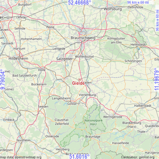
Gielde GPS coordinates[2]
52° 2' 10.428" North, 10° 29' 37.176" East
| Map corner | latitude | longitude |
|---|---|---|
| Upper-left | 52.46668°, | 9.79054° |
| Center: | 52.03623°, | 10.49366° |
| Lower-right: | 51.6016°, | 11.19679° |
| Map W x H: | 96.2×96.2 km | = 59.8×59.8mi |
| max Lat: | 55.01917° ⇑27.6% North |
| Gielde: | 52.03623° |
| min Lat: | ⇓72.4% South 47.40724° |
| min Long | Gielde | max Long |
| 5.92978° | 10.49366° | 14.98853° |
| W 58.8%⇐ | ⇒41.2% E |
Elevation
Elevation of Gielde is 93 m = 305 ft, and this is 156.1 m = 512 ft below average elevation for this country.
| Max E: |
1256 m = 4121 ft | 69.7% |
| Avg. | 249.1 m = 817 ft | |
| Gielde | 93 m = 305 ft | |
Min E: |
-5 m = -16 ft | 30.3% |
See also: Germany elevation on elevation.city.
Geographical zone
Gielde is located in North temperate zone (between Tropic of Cancer and the Arctic Circle). Distance of this North polar circle is 1615.3 km =1003.7 mi to North.| Distance of | km | miles | from Gielde |
|---|---|---|---|
| North Pole | 4221.2 | 2622.9 | to North |
| Arctic Circle | 1615.3 | 1003.7 | to North |
| Tropic Cancer | 3180 | 1976 | to South |
| Equator | 5785.9 | 3595.2 | to South |


Nearby cities:
15 places around Gielde: (largest is in red/bold)
• Achim
8.4 km =5.2 mi,  72°
72°
• Alt Wallmoden
13.2 km =8.2 mi,  261°
261°
• Börßum
7.2 km =4.5 mi,  59°
59°
• Cramme
9.2 km =5.7 mi,  339°
339°
• Dorstadt
8.7 km =5.4 mi,  35°
35°
• Flöthe
5.3 km =3.3 mi,  352°
352°
• Heiningen
5.6 km =3.5 mi,  48°
48°
• Hornburg
7.6 km =4.7 mi,  94°
94°
• Kissenbrück
10.5 km =6.5 mi, 38°
• Liebenburg
4.5 km =2.8 mi,  249°
249°
• Ohrum
10.5 km =6.5 mi,  26°
26°
• Schladen
3.5 km =2.2 mi,  116°
116°
• Vienenburg
10.5 km =6.5 mi,  152°
152°
• Werlaburgdorf
3.3 km =2.1 mi, 62°
• Wülperode
9.4 km =5.8 mi,  130°
130°
Sources, notices
• [Note1] Compared only with cities in Germany existing in our database
• [Src1] Map data: © OpenStreetMap contributors (CC-BY-SA)
• [Src2] Other city data from geonames.org with taken over terms of usage.
• [Src3] Geographical zone / Annual Mean Temperature by Robert A. Rohde @ Wikipedia
