Roklum geodata
Roklum (Lower Saxony) is a seat of a fourth-order administrative division; located in Germany in Europe/Berlin (GMT+2) time zone. With population of 511 people, there are 9318 cities with bigger population in this country. Compared to other cities in Germany, 72.7% of cities are located further ↓South; 63.2% of cities are located further ←West and 65.6% of cities have higher elevation than Roklum. Note1


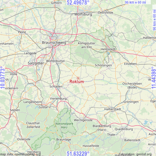
Roklum GPS coordinates[2]
52° 3' 59.868" North, 10° 44' 27.06" East
| Map corner | latitude | longitude |
|---|---|---|
| Upper-left | 52.49678°, | 10.03773° |
| Center: | 52.06663°, | 10.74085° |
| Lower-right: | 51.63229°, | 11.44398° |
| Map W x H: | 96.1×96.1 km | = 59.7×59.7mi |
| max Lat: | 55.01917° ⇑27.3% North |
| Roklum: | 52.06663° |
| min Lat: | ⇓72.7% South 47.40724° |
| min Long | Roklum | max Long |
| 5.92978° | 10.74085° | 14.98853° |
| W 63.2%⇐ | ⇒36.8% E |
Elevation
Elevation of Roklum is 117 m = 384 ft, and this is 132.1 m = 433 ft below average elevation for this country.
| Max E: |
1256 m = 4121 ft | 65.6% |
| Avg. | 249.1 m = 817 ft | |
| Roklum | 117 m = 384 ft | |
Min E: |
-5 m = -16 ft | 34.4% |
See also: Germany elevation on elevation.city.
Geographical zone
Roklum is located in North temperate zone (between Tropic of Cancer and the Arctic Circle). Distance of this North polar circle is 1611.9 km =1001.6 mi to North.| Distance of | km | miles | from Roklum |
|---|---|---|---|
| North Pole | 4217.8 | 2620.8 | to North |
| Arctic Circle | 1611.9 | 1001.6 | to North |
| Tropic Cancer | 3183.3 | 1978 | to South |
| Equator | 5789.3 | 3597.3 | to South |


Nearby cities:
15 places around Roklum: (largest is in red/bold)
• Achim
8.9 km =5.5 mi,  264°
264°
• Beierstedt
8.1 km =5 mi,  84°
84°
• Börßum
10.7 km =6.6 mi,  271°
271°
• Dahlum
10.5 km =6.5 mi,  45°
45°
• Gevensleben
5.7 km =3.5 mi, 78°
• Hedeper
3.9 km =2.4 mi, 270°
• Hornburg
10.1 km =6.3 mi,  246°
246°
• Ingeleben
10.1 km =6.3 mi,  63°
63°
• Remlingen
6.9 km =4.3 mi,  318°
318°
• Schöppenstedt
8.8 km =5.5 mi,  15°
15°
• Semmenstedt
4.3 km =2.7 mi, 315°
• Uehrde
4 km =2.5 mi, 24°
• Vahlberg
7.6 km =4.7 mi,  347°
347°
• Winnigstedt
1.9 km =1.2 mi,  91°
91°
• Wittmar
9.8 km =6.1 mi, 315°
Sources, notices
• [Note1] Compared only with cities in Germany existing in our database
• [Src1] Map data: © OpenStreetMap contributors (CC-BY-SA)
• [Src2] Other city data from geonames.org with taken over terms of usage.
• [Src3] Geographical zone / Annual Mean Temperature by Robert A. Rohde @ Wikipedia
