Homberg geodata
Homberg (Rheinland-Pfalz) is a seat of a fourth-order administrative division; located in Germany in Europe/Berlin (GMT+2) time zone. In our database, there are 11009 cities with bigger population. Compared to other cities in Germany, 50.5% of cities are located further ↓South; 75.4% of cities are located further →East and 95.7% of cities have lower elevation than Homberg. Note1


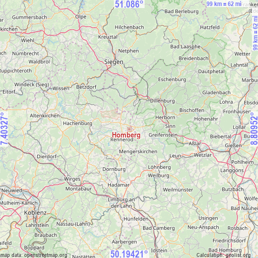
Homberg GPS coordinates[2]
50° 38' 31.992" North, 8° 6' 23.004" East
| Map corner | latitude | longitude |
|---|---|---|
| Upper-left | 51.086°, | 7.40327° |
| Center: | 50.64222°, | 8.10639° |
| Lower-right: | 50.19421°, | 8.80952° |
| Map W x H: | 99.2×99.2 km | = 61.6×61.6mi |
| max Lat: | 55.01917° ⇑49.5% North |
| Homberg: | 50.64222° |
| min Lat: | ⇓50.5% South 47.40724° |
| min Long | Homberg | max Long |
| 5.92978° | 8.10639° | 14.98853° |
| W 24.6%⇐ | ⇒75.4% E |
Elevation
Elevation of Homberg is 615 m = 2018 ft, and this is 365.9 m = 1200 ft above average elevation for this country.
| Max E: |
1256 m = 4121 ft | 4.3% |
| Homberg | 615 m 2018 ft | |
| Avg. | 249.1 m = 817 ft | |
Min E: |
-5 m = -16 ft | 95.7% |
See also: Germany elevation on elevation.city.
Geographical zone
Homberg is located in North temperate zone (between Tropic of Cancer and the Arctic Circle). Distance of this North polar circle is 1770.3 km =1100 mi to North.| Distance of | km | miles | from Homberg |
|---|---|---|---|
| North Pole | 4376.2 | 2719.2 | to North |
| Arctic Circle | 1770.3 | 1100 | to North |
| Tropic Cancer | 3025 | 1879.6 | to South |
| Equator | 5630.9 | 3498.9 | to South |


Nearby cities:
15 places around Homberg: (largest is in red/bold)
• Bretthausen
3.9 km =2.4 mi,  314°
314°
• Driedorf
5.5 km =3.4 mi,  100°
100°
• Liebenscheid
6.1 km =3.8 mi,  354°
354°
• Neustadt/Westerwald
4.9 km =3 mi,  253°
253°
• Niederroßbach
5.1 km =3.2 mi,  269°
269°
• Oberrod
6.5 km =4 mi,  166°
166°
• Oberroßbach
4.9 km =3 mi,  286°
286°
• Rehe
1.2 km =0.7 mi,  143°
143°
• Rennerod
4.7 km =2.9 mi,  216°
216°
• Salzburg
4.8 km =3 mi,  304°
304°
• Stein-Neukirch
5.2 km =3.2 mi,  315°
315°
• Waigandshain
1.5 km =0.9 mi,  280°
280°
• Westernohe
5.9 km =3.7 mi,  184°
184°
• Willingen
3.1 km =1.9 mi,  335°
335°
• Zehnhausen bei Rennerod
3.3 km =2.1 mi, 279°
Sources, notices
• [Note1] Compared only with cities in Germany existing in our database
• [Src1] Map data: © OpenStreetMap contributors (CC-BY-SA)
• [Src2] Other city data from geonames.org with taken over terms of usage.
• [Src3] Geographical zone / Annual Mean Temperature by Robert A. Rohde @ Wikipedia
