Oberrod geodata
Oberrod (Rheinland-Pfalz) is a seat of a fourth-order administrative division; located in Germany in Europe/Berlin (GMT+2) time zone. With population of 736 people, there are 8166 cities with bigger population in this country. Compared to other cities in Germany, 50.8% of cities are located further ↑North; 75% of cities are located further →East and 79.9% of cities have lower elevation than Oberrod. Note1


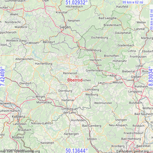
Oberrod GPS coordinates[2]
50° 35' 6" North, 8° 7' 37.992" East
| Map corner | latitude | longitude |
|---|---|---|
| Upper-left | 51.02932°, | 7.42409° |
| Center: | 50.585°, | 8.12722° |
| Lower-right: | 50.13644°, | 8.83034° |
| Map W x H: | 99.3×99.3 km | = 61.7×61.7mi |
| max Lat: | 55.01917° ⇑50.8% North |
| Oberrod: | 50.585° |
| min Lat: | ⇓49.2% South 47.40724° |
| min Long | Oberrod | max Long |
| 5.92978° | 8.12722° | 14.98853° |
| W 25%⇐ | ⇒75% E |
Elevation
Elevation of Oberrod is 432 m = 1417 ft, and this is 182.9 m = 600 ft above average elevation for this country.
| Max E: |
1256 m = 4121 ft | 20.1% |
| Oberrod | 432 m 1417 ft | |
| Avg. | 249.1 m = 817 ft | |
Min E: |
-5 m = -16 ft | 79.9% |
See also: Germany elevation on elevation.city.
Geographical zone
Oberrod is located in North temperate zone (between Tropic of Cancer and the Arctic Circle). Distance of this North polar circle is 1776.6 km =1103.9 mi to North.| Distance of | km | miles | from Oberrod |
|---|---|---|---|
| North Pole | 4382.5 | 2723.2 | to North |
| Arctic Circle | 1776.6 | 1103.9 | to North |
| Tropic Cancer | 3018.6 | 1875.7 | to South |
| Equator | 5624.5 | 3494.9 | to South |


Nearby cities:
15 places around Oberrod: (largest is in red/bold)
• Driedorf
6.7 km =4.2 mi,  36°
36°
• Elsoff
1.3 km =0.8 mi,  217°
217°
• Hellenhahn-Schellenberg
7.8 km =4.8 mi,  293°
293°
• Homberg
6.5 km =4 mi,  346°
346°
• Hüblingen
3.7 km =2.3 mi,  236°
236°
• Irmtraut
5.8 km =3.6 mi,  227°
227°
• Mengerskirchen
3.1 km =1.9 mi,  139°
139°
• Neunkirchen
4.5 km =2.8 mi,  201°
201°
• Rehe
5.4 km =3.4 mi, 352°
• Rennerod
5 km =3.1 mi,  301°
301°
• Seck
5.5 km =3.4 mi,  261°
261°
• Waigandshain
7.3 km =4.5 mi,  335°
335°
• Waldbrunn
7.5 km =4.7 mi,  190°
190°
• Waldmühlen
4.3 km =2.7 mi,  267°
267°
• Westernohe
2 km =1.2 mi,  283°
283°
Sources, notices
• [Note1] Compared only with cities in Germany existing in our database
• [Src1] Map data: © OpenStreetMap contributors (CC-BY-SA)
• [Src2] Other city data from geonames.org with taken over terms of usage.
• [Src3] Geographical zone / Annual Mean Temperature by Robert A. Rohde @ Wikipedia
