Driedorf geodata
Driedorf (Hesse) is a seat of a fourth-order administrative division; located in Germany in Europe/Berlin (GMT+2) time zone. With population of 5,213 people, there are 2730 cities with bigger population in this country. Compared to other cities in Germany, 50.3% of cities are located further ↓South; 74.3% of cities are located further →East and 86.9% of cities have lower elevation than Driedorf. Note1
Administrative division(s):
- Level 1: Hesse
- Level 2: Regierungsbezirk Gießen
- Level 3: Lahn-Dill-Kreis
- Level 4: Driedorf


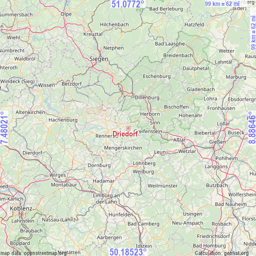
Driedorf GPS coordinates[2]
50° 37' 59.988" North, 8° 10' 59.988" East
| Map corner | latitude | longitude |
|---|---|---|
| Upper-left | 51.0772°, | 7.48021° |
| Center: | 50.63333°, | 8.18333° |
| Lower-right: | 50.18523°, | 8.88646° |
| Map W x H: | 99.2×99.2 km | = 61.6×61.6mi |
| max Lat: | 55.01917° ⇑49.7% North |
| Driedorf: | 50.63333° |
| min Lat: | ⇓50.3% South 47.40724° |
| min Long | Driedorf | max Long |
| 5.92978° | 8.18333° | 14.98853° |
| W 25.7%⇐ | ⇒74.3% E |
Elevation
Elevation of Driedorf is 485 m = 1591 ft, and this is 235.9 m = 774 ft above average elevation for this country.
| Max E: |
1256 m = 4121 ft | 13.1% |
| Driedorf | 485 m 1591 ft | |
| Avg. | 249.1 m = 817 ft | |
Min E: |
-5 m = -16 ft | 86.9% |
See also: Germany elevation on elevation.city.
Geographical zone
Driedorf is located in North temperate zone (between Tropic of Cancer and the Arctic Circle). Distance of this North polar circle is 1771.3 km =1100.6 mi to North.| Distance of | km | miles | from Driedorf |
|---|---|---|---|
| North Pole | 4377.2 | 2719.9 | to North |
| Arctic Circle | 1771.3 | 1100.6 | to North |
| Tropic Cancer | 3024 | 1879 | to South |
| Equator | 5629.9 | 3498.3 | to South |


Nearby cities:
15 places around Driedorf: (largest is in red/bold)
• Breitscheid
5.8 km =3.6 mi,  5°
5°
• Bretthausen
9 km =5.6 mi,  294°
294°
• Elsoff
8 km =5 mi,  216°
216°
• Greifenstein
8.4 km =5.2 mi,  102°
102°
• Homberg
5.5 km =3.4 mi,  280°
280°
• Liebenscheid
9.3 km =5.8 mi,  319°
319°
• Mengerskirchen
8 km =5 mi,  194°
194°
• Merkenbach
8.3 km =5.2 mi,  72°
72°
• Oberrod
6.7 km =4.2 mi, 216°
• Rehe
4.7 km =2.9 mi,  270°
270°
• Rennerod
8.7 km =5.4 mi,  251°
251°
• Waigandshain
7 km =4.3 mi, 280°
• Westernohe
7.6 km =4.7 mi,  230°
230°
• Willingen
7.7 km =4.8 mi,  299°
299°
• Zehnhausen bei Rennerod
8.9 km =5.5 mi, 280°
Sources, notices
• [Note1] Compared only with cities in Germany existing in our database
• [Src1] Map data: © OpenStreetMap contributors (CC-BY-SA)
• [Src2] Other city data from geonames.org with taken over terms of usage.
• [Src3] Geographical zone / Annual Mean Temperature by Robert A. Rohde @ Wikipedia
