Holzminden geodata
Holzminden (Lower Saxony) is a seat of a third-order administrative division; located in Germany in Europe/Berlin (GMT+2) time zone. With population of 20,998 people, there are 728 cities with bigger population in this country. Compared to other cities in Germany, 70.2% of cities are located further ↓South; 58.7% of cities are located further →East and 70% of cities have higher elevation than Holzminden. Note1


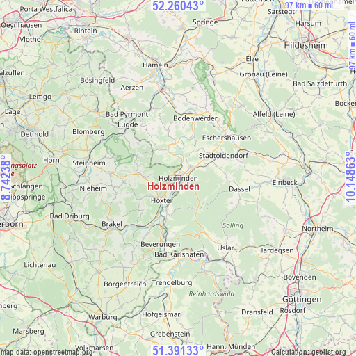
Holzminden GPS coordinates[2]
51° 49' 40.728" North, 9° 26' 43.8" East
| Map corner | latitude | longitude |
|---|---|---|
| Upper-left | 52.26043°, | 8.74238° |
| Center: | 51.82798°, | 9.4455° |
| Lower-right: | 51.39133°, | 10.14863° |
| Map W x H: | 96.6×96.6 km | = 60×60mi |
| max Lat: | 55.01917° ⇑29.8% North |
| Holzminden: | 51.82798° |
| min Lat: | ⇓70.2% South 47.40724° |
| min Long | Holzminden | max Long |
| 5.92978° | 9.4455° | 14.98853° |
| W 41.3%⇐ | ⇒58.7% E |
Elevation
Elevation of Holzminden is 91 m = 299 ft, and this is 158.1 m = 519 ft below average elevation for this country.
| Max E: |
1256 m = 4121 ft | 70% |
| Avg. | 249.1 m = 817 ft | |
| Holzminden | 91 m = 299 ft | |
Min E: |
-5 m = -16 ft | 30% |
See also: Germany elevation on elevation.city.
Geographical zone
Holzminden is located in North temperate zone (between Tropic of Cancer and the Arctic Circle). Distance of this North polar circle is 1638.4 km =1018.1 mi to North.| Distance of | km | miles | from Holzminden |
|---|---|---|---|
| North Pole | 4244.3 | 2637.3 | to North |
| Arctic Circle | 1638.4 | 1018.1 | to North |
| Tropic Cancer | 3156.8 | 1961.5 | to South |
| Equator | 5762.7 | 3580.8 | to South |


Nearby cities:
15 places around Holzminden: (largest is in red/bold)
• Arholzen
9.4 km =5.8 mi,  62°
62°
• Bevern
4.7 km =2.9 mi,  44°
44°
• Boffzen
9.7 km =6 mi,  206°
206°
• Brevörde
10.1 km =6.3 mi,  348°
348°
• Deensen
10.8 km =6.7 mi,  70°
70°
• Fürstenberg
11 km =6.8 mi,  196°
196°
• Golmbach
10.8 km =6.7 mi, 41°
• Heinade
12.9 km =8 mi,  87°
87°
• Heinsen
6.2 km =3.9 mi, 352°
• Höxter
7.4 km =4.6 mi,  216°
216°
• Negenborn
10.3 km =6.4 mi,  53°
53°
• Ottenstein
13.5 km =8.4 mi, 348°
• Pegestorf
11.6 km =7.2 mi,  17°
17°
• Polle
8.4 km =5.2 mi,  340°
340°
• Vahlbruch
12.6 km =7.8 mi,  325°
325°
Sources, notices
• [Note1] Compared only with cities in Germany existing in our database
• [Src1] Map data: © OpenStreetMap contributors (CC-BY-SA)
• [Src2] Other city data from geonames.org with taken over terms of usage.
• [Src3] Geographical zone / Annual Mean Temperature by Robert A. Rohde @ Wikipedia
