Höxter geodata
Höxter (North Rhine-Westphalia) is a seat of a third-order administrative division; located in Germany in Europe/Berlin (GMT+2) time zone. With population of 32,713 people, there are 415 cities with bigger population in this country. Compared to other cities in Germany, 69.7% of cities are located further ↓South; 59.6% of cities are located further →East and 68.5% of cities have higher elevation than Höxter. Note1
Administrative division(s):
- Level 1: North Rhine-Westphalia
- Level 2: Regierungsbezirk Detmold
- Level 3: Kreis Höxter
- Level 4: Höxter


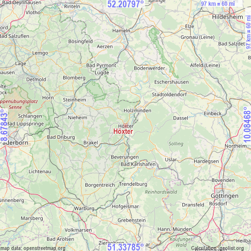
Höxter GPS coordinates[2]
51° 46' 30.036" North, 9° 22' 53.58" East
| Map corner | latitude | longitude |
|---|---|---|
| Upper-left | 52.20797°, | 8.67843° |
| Center: | 51.77501°, | 9.38155° |
| Lower-right: | 51.33785°, | 10.08468° |
| Map W x H: | 96.7×96.7 km | = 60.1×60.1mi |
| max Lat: | 55.01917° ⇑30.3% North |
| Höxter: | 51.77501° |
| min Lat: | ⇓69.7% South 47.40724° |
| min Long | Höxter | max Long |
| 5.92978° | 9.38155° | 14.98853° |
| W 40.4%⇐ | ⇒59.6% E |
Elevation
Elevation of Höxter is 100 m = 328 ft, and this is 149.1 m = 489 ft below average elevation for this country.
| Max E: |
1256 m = 4121 ft | 68.5% |
| Avg. | 249.1 m = 817 ft | |
| Höxter | 100 m = 328 ft | |
Min E: |
-5 m = -16 ft | 31.5% |
See also: Germany elevation on elevation.city.
Geographical zone
Höxter is located in North temperate zone (between Tropic of Cancer and the Arctic Circle). Distance of this North polar circle is 1644.3 km =1021.7 mi to North.| Distance of | km | miles | from Höxter |
|---|---|---|---|
| North Pole | 4250.2 | 2641 | to North |
| Arctic Circle | 1644.3 | 1021.7 | to North |
| Tropic Cancer | 3150.9 | 1957.9 | to South |
| Equator | 5756.8 | 3577.1 | to South |


Nearby cities:
15 places around Höxter: (largest is in red/bold)
• Arholzen
16.3 km =10.1 mi,  51°
51°
• Bad Karlshafen
15.6 km =9.7 mi,  161°
161°
• Bevern
12.1 km =7.5 mi,  39°
39°
• Beverungen
11.9 km =7.4 mi,  182°
182°
• Boffzen
2.8 km =1.7 mi, 177°
• Brakel
14.9 km =9.3 mi,  244°
244°
• Brevörde
15.9 km =9.9 mi,  8°
8°
• Deensen
17.4 km =10.8 mi,  56°
56°
• Derental
9.6 km =6 mi, 158°
• Fürstenberg
4.8 km =3 mi, 164°
• Heinsen
12.6 km =7.8 mi,  16°
16°
• Holzminden
7.4 km =4.6 mi, 36°
• Polle
13.8 km =8.6 mi, 6°
• Schieder-Schwalenberg
17.1 km =10.6 mi,  311°
311°
• Vahlbruch
16.4 km =10.2 mi,  350°
350°
Sources, notices
• [Note1] Compared only with cities in Germany existing in our database
• [Src1] Map data: © OpenStreetMap contributors (CC-BY-SA)
• [Src2] Other city data from geonames.org with taken over terms of usage.
• [Src3] Geographical zone / Annual Mean Temperature by Robert A. Rohde @ Wikipedia
