Netzbach geodata
Netzbach (Rheinland-Pfalz) is a seat of a fourth-order administrative division; located in Germany in Europe/Berlin (GMT+2) time zone. In our database, there are 11009 cities with bigger population. Compared to other cities in Germany, 56.5% of cities are located further ↑North; 75.5% of cities are located further →East and 52.9% of cities have higher elevation than Netzbach. Note1


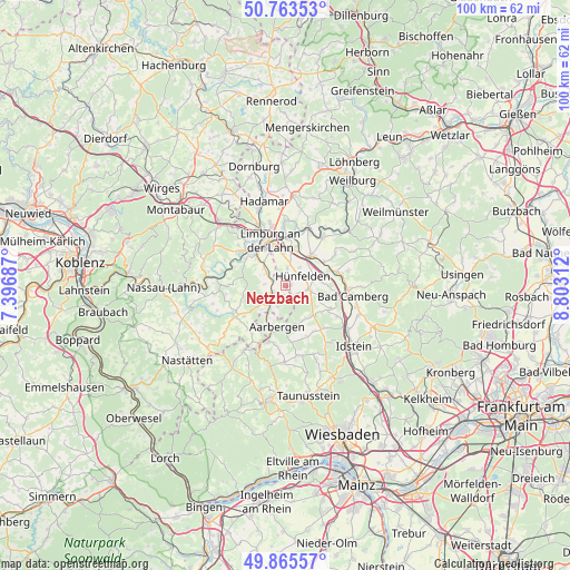
Netzbach GPS coordinates[2]
50° 19' 0.012" North, 8° 6' 0" East
| Map corner | latitude | longitude |
|---|---|---|
| Upper-left | 50.76353°, | 7.39687° |
| Center: | 50.31667°, | 8.1° |
| Lower-right: | 49.86557°, | 8.80312° |
| Map W x H: | 99.8×99.8 km | = 62×62mi |
| max Lat: | 55.01917° ⇑56.5% North |
| Netzbach: | 50.31667° |
| min Lat: | ⇓43.5% South 47.40724° |
| min Long | Netzbach | max Long |
| 5.92978° | 8.1° | 14.98853° |
| W 24.5%⇐ | ⇒75.5% E |
Elevation
Elevation of Netzbach is 205 m = 673 ft, and this is 44.1 m = 145 ft below average elevation for this country.
| Max E: |
1256 m = 4121 ft | 52.9% |
| Avg. | 249.1 m = 817 ft | |
| Netzbach | 205 m = 673 ft | |
Min E: |
-5 m = -16 ft | 47.1% |
See also: Germany elevation on elevation.city.
Geographical zone
Netzbach is located in North temperate zone (between Tropic of Cancer and the Arctic Circle). Distance of this North polar circle is 1806.5 km =1122.5 mi to North.| Distance of | km | miles | from Netzbach |
|---|---|---|---|
| North Pole | 4412.4 | 2741.7 | to North |
| Arctic Circle | 1806.5 | 1122.5 | to North |
| Tropic Cancer | 2988.8 | 1857.2 | to South |
| Equator | 5594.7 | 3476.4 | to South |


Nearby cities:
15 places around Netzbach: (largest is in red/bold)
• Allendorf
9 km =5.6 mi,  232°
232°
• Birlenbach
8.3 km =5.2 mi,  303°
303°
• Burgschwalbach
3.9 km =2.4 mi,  197°
197°
• Ebertshausen
9.1 km =5.7 mi,  245°
245°
• Flacht
4.8 km =3 mi,  312°
312°
• Hahnstätten
3 km =1.9 mi, 231°
• Holzheim
5.6 km =3.5 mi,  318°
318°
• Kaltenholzhausen
1.9 km =1.2 mi,  180°
180°
• Limburg an der Lahn
8.2 km =5.1 mi,  334°
334°
• Lohrheim
3.5 km =2.2 mi,  270°
270°
• Mudershausen
6 km =3.7 mi, 231°
• Niederneisen
4 km =2.5 mi, 297°
• Oberneisen
1.9 km =1.2 mi, 301°
• Schiesheim
5.4 km =3.4 mi,  216°
216°
• Schönborn
7.7 km =4.8 mi,  258°
258°
Sources, notices
• [Note1] Compared only with cities in Germany existing in our database
• [Src1] Map data: © OpenStreetMap contributors (CC-BY-SA)
• [Src2] Other city data from geonames.org with taken over terms of usage.
• [Src3] Geographical zone / Annual Mean Temperature by Robert A. Rohde @ Wikipedia
