Lohrheim geodata
Lohrheim (Rheinland-Pfalz) is a seat of a fourth-order administrative division; located in Germany in Europe/Berlin (GMT+2) time zone. With population of 581 people, there are 8916 cities with bigger population in this country. Compared to other cities in Germany, 56.5% of cities are located further ↑North; 76.3% of cities are located further →East and 55.1% of cities have higher elevation than Lohrheim. Note1


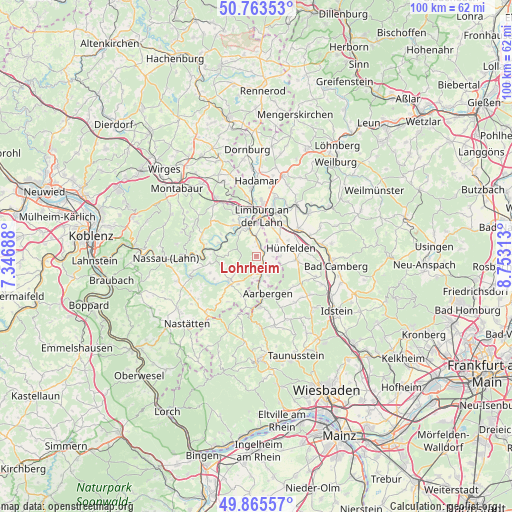
Lohrheim GPS coordinates[2]
50° 19' 0.012" North, 8° 3' 0" East
| Map corner | latitude | longitude |
|---|---|---|
| Upper-left | 50.76353°, | 7.34688° |
| Center: | 50.31667°, | 8.05° |
| Lower-right: | 49.86557°, | 8.75313° |
| Map W x H: | 99.8×99.8 km | = 62×62mi |
| max Lat: | 55.01917° ⇑56.5% North |
| Lohrheim: | 50.31667° |
| min Lat: | ⇓43.5% South 47.40724° |
| min Long | Lohrheim | max Long |
| 5.92978° | 8.05° | 14.98853° |
| W 23.7%⇐ | ⇒76.3% E |
Elevation
Elevation of Lohrheim is 187 m = 614 ft, and this is 62.1 m = 204 ft below average elevation for this country.
| Max E: |
1256 m = 4121 ft | 55.1% |
| Avg. | 249.1 m = 817 ft | |
| Lohrheim | 187 m = 614 ft | |
Min E: |
-5 m = -16 ft | 44.9% |
See also: Germany elevation on elevation.city.
Geographical zone
Lohrheim is located in North temperate zone (between Tropic of Cancer and the Arctic Circle). Distance of this North polar circle is 1806.5 km =1122.5 mi to North.| Distance of | km | miles | from Lohrheim |
|---|---|---|---|
| North Pole | 4412.4 | 2741.7 | to North |
| Arctic Circle | 1806.5 | 1122.5 | to North |
| Tropic Cancer | 2988.8 | 1857.2 | to South |
| Equator | 5594.7 | 3476.4 | to South |


Nearby cities:
15 places around Lohrheim: (largest is in red/bold)
• Allendorf
6.5 km =4 mi,  213°
213°
• Birlenbach
5.7 km =3.5 mi,  323°
323°
• Burgschwalbach
4.4 km =2.7 mi,  147°
147°
• Ebertshausen
6 km =3.7 mi,  231°
231°
• Flacht
3.2 km =2 mi,  0°
0°
• Hahnstätten
2.2 km =1.4 mi, 147°
• Holzheim
4.2 km =2.6 mi,  358°
358°
• Kaltenholzhausen
4 km =2.5 mi,  117°
117°
• Mudershausen
3.9 km =2.4 mi,  197°
197°
• Netzbach
3.5 km =2.2 mi,  90°
90°
• Niederneisen
1.9 km =1.2 mi, 0°
• Oberneisen
2.2 km =1.4 mi,  62°
62°
• Schiesheim
4.4 km =2.7 mi,  175°
175°
• Schönborn
4.3 km =2.7 mi,  248°
248°
• Wasenbach
5.9 km =3.7 mi,  270°
270°
Sources, notices
• [Note1] Compared only with cities in Germany existing in our database
• [Src1] Map data: © OpenStreetMap contributors (CC-BY-SA)
• [Src2] Other city data from geonames.org with taken over terms of usage.
• [Src3] Geographical zone / Annual Mean Temperature by Robert A. Rohde @ Wikipedia
