Hahnstätten geodata
Hahnstätten (Rheinland-Pfalz) is a seat of a fourth-order administrative division; located in Germany in Europe/Berlin (GMT+2) time zone. With population of 2,900 people, there are 4091 cities with bigger population in this country. Compared to other cities in Germany, 56.8% of cities are located further ↑North; 76% of cities are located further →East and 60.9% of cities have higher elevation than Hahnstätten. Note1


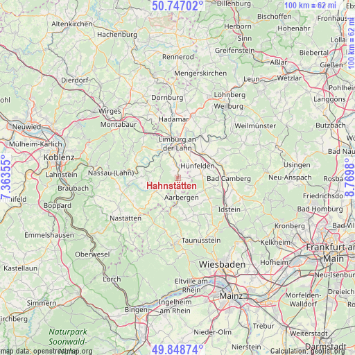
Hahnstätten GPS coordinates[2]
50° 18' 0" North, 8° 4' 0.012" East
| Map corner | latitude | longitude |
|---|---|---|
| Upper-left | 50.74702°, | 7.36355° |
| Center: | 50.3°, | 8.06667° |
| Lower-right: | 49.84874°, | 8.7698° |
| Map W x H: | 99.9×99.9 km | = 62.1×62.1mi |
| max Lat: | 55.01917° ⇑56.8% North |
| Hahnstätten: | 50.3° |
| min Lat: | ⇓43.2% South 47.40724° |
| min Long | Hahnstätten | max Long |
| 5.92978° | 8.06667° | 14.98853° |
| W 24%⇐ | ⇒76% E |
Elevation
Elevation of Hahnstätten is 146 m = 479 ft, and this is 103.1 m = 338 ft below average elevation for this country.
| Max E: |
1256 m = 4121 ft | 60.9% |
| Avg. | 249.1 m = 817 ft | |
| Hahnstätten | 146 m = 479 ft | |
Min E: |
-5 m = -16 ft | 39.1% |
See also: Germany elevation on elevation.city.
Geographical zone
Hahnstätten is located in North temperate zone (between Tropic of Cancer and the Arctic Circle). Distance of this North polar circle is 1808.3 km =1123.6 mi to North.| Distance of | km | miles | from Hahnstätten |
|---|---|---|---|
| North Pole | 4414.2 | 2742.9 | to North |
| Arctic Circle | 1808.3 | 1123.6 | to North |
| Tropic Cancer | 2986.9 | 1856 | to South |
| Equator | 5592.8 | 3475.2 | to South |


Nearby cities:
15 places around Hahnstätten: (largest is in red/bold)
• Allendorf
6 km =3.7 mi,  233°
233°
• Berghausen
6.2 km =3.9 mi,  222°
222°
• Burgschwalbach
2.2 km =1.4 mi,  147°
147°
• Dörsdorf
7.2 km =4.5 mi,  214°
214°
• Ebertshausen
6.2 km =3.9 mi,  252°
252°
• Flacht
5.2 km =3.2 mi,  346°
346°
• Holzheim
6.2 km =3.9 mi, 347°
• Kaltenholzhausen
2.4 km =1.5 mi,  90°
90°
• Lohrheim
2.2 km =1.4 mi,  327°
327°
• Mudershausen
3 km =1.9 mi, 231°
• Netzbach
3 km =1.9 mi,  51°
51°
• Niederneisen
3.9 km =2.4 mi,  342°
342°
• Oberneisen
2.9 km =1.8 mi,  14°
14°
• Schiesheim
2.7 km =1.7 mi,  198°
198°
• Schönborn
5.2 km =3.2 mi,  273°
273°
Sources, notices
• [Note1] Compared only with cities in Germany existing in our database
• [Src1] Map data: © OpenStreetMap contributors (CC-BY-SA)
• [Src2] Other city data from geonames.org with taken over terms of usage.
• [Src3] Geographical zone / Annual Mean Temperature by Robert A. Rohde @ Wikipedia
