Kaulsdorf geodata
Kaulsdorf (Thuringia) is a seat of a fourth-order administrative division; located in Germany in Europe/Berlin (GMT+2) time zone. With population of 2,980 people, there are 4020 cities with bigger population in this country. Compared to other cities in Germany, 50% of cities are located further ↓South; 73.2% of cities are located further ←West and 53.6% of cities have lower elevation than Kaulsdorf. Note1


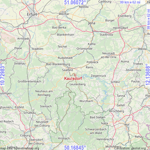
Kaulsdorf GPS coordinates[2]
50° 37' 0.12" North, 11° 25' 58.62" East
| Map corner | latitude | longitude |
|---|---|---|
| Upper-left | 51.06072°, | 10.72983° |
| Center: | 50.6167°, | 11.43295° |
| Lower-right: | 50.16845°, | 12.13608° |
| Map W x H: | 99.2×99.2 km | = 61.6×61.6mi |
| max Lat: | 55.01917° ⇑50% North |
| Kaulsdorf: | 50.6167° |
| min Lat: | ⇓50% South 47.40724° |
| min Long | Kaulsdorf | max Long |
| 5.92978° | 11.43295° | 14.98853° |
| W 73.2%⇐ | ⇒26.8% E |
Elevation
Elevation of Kaulsdorf is 250 m = 820 ft, and this is 0.90000000000001 m = 3 ft above average elevation for this country.
| Max E: |
1256 m = 4121 ft | 46.4% |
| Kaulsdorf | 250 m 820 ft | |
| Avg. | 249.1 m = 817 ft | |
Min E: |
-5 m = -16 ft | 53.6% |
See also: Germany elevation on elevation.city.
Geographical zone
Kaulsdorf is located in North temperate zone (between Tropic of Cancer and the Arctic Circle). Distance of this North polar circle is 1773.1 km =1101.8 mi to North.| Distance of | km | miles | from Kaulsdorf |
|---|---|---|---|
| North Pole | 4379 | 2721 | to North |
| Arctic Circle | 1773.1 | 1101.8 | to North |
| Tropic Cancer | 3022.1 | 1877.8 | to South |
| Equator | 5628 | 3497.1 | to South |


Nearby cities:
15 places around Kaulsdorf: (largest is in red/bold)
• Birkigt
6.9 km =4.3 mi,  31°
31°
• Drognitz
10.3 km =6.4 mi,  108°
108°
• Goßwitz
3.8 km =2.4 mi,  56°
56°
• Hohenwarte
4 km =2.5 mi,  117°
117°
• Kamsdorf
3.3 km =2.1 mi, 26°
• Krölpa
10 km =6.2 mi,  47°
47°
• Könitz
5.4 km =3.4 mi, 46°
• Leutenberg
6.1 km =3.8 mi,  164°
164°
• Marktgölitz
9.6 km =6 mi,  225°
225°
• Probstzella
9.9 km =6.2 mi,  200°
200°
• Reichenbach
7.6 km =4.7 mi,  1°
1°
• Saalfeld
5.9 km =3.7 mi,  306°
306°
• Seisla
8.1 km =5 mi, 62°
• Unterwellenborn
3.7 km =2.3 mi, 0°
• Wilhelmsdorf
8.4 km =5.2 mi,  80°
80°
Sources, notices
• [Note1] Compared only with cities in Germany existing in our database
• [Src1] Map data: © OpenStreetMap contributors (CC-BY-SA)
• [Src2] Other city data from geonames.org with taken over terms of usage.
• [Src3] Geographical zone / Annual Mean Temperature by Robert A. Rohde @ Wikipedia
