Berga geodata
Berga (Thuringia) is a populated place; located in Germany in Europe/Berlin (GMT+2) time zone. With population of 3,869 people, there are 3366 cities with bigger population in this country. Compared to other cities in Germany, 53.4% of cities are located further ↓South; 84.1% of cities are located further ←West and 52% of cities have lower elevation than Berga. Note1


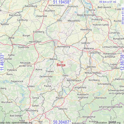
Berga GPS coordinates[2]
50° 45' 6.624" North, 12° 9' 52.02" East
| Map corner | latitude | longitude |
|---|---|---|
| Upper-left | 51.19458°, | 11.46133° |
| Center: | 50.75184°, | 12.16445° |
| Lower-right: | 50.30487°, | 12.86758° |
| Map W x H: | 98.9×98.9 km | = 61.5×61.5mi |
| max Lat: | 55.01917° ⇑46.6% North |
| Berga: | 50.75184° |
| min Lat: | ⇓53.4% South 47.40724° |
| min Long | Berga | max Long |
| 5.92978° | 12.16445° | 14.98853° |
| W 84.1%⇐ | ⇒15.9% E |
Elevation
Elevation of Berga is 240 m = 787 ft, and this is 9.1 m = 30 ft below average elevation for this country.
| Max E: |
1256 m = 4121 ft | 48% |
| Avg. | 249.1 m = 817 ft | |
| Berga | 240 m = 787 ft | |
Min E: |
-5 m = -16 ft | 52% |
See also: Germany elevation on elevation.city.
Geographical zone
Berga is located in North temperate zone (between Tropic of Cancer and the Arctic Circle). Distance of this North polar circle is 1758.1 km =1092.4 mi to North.| Distance of | km | miles | from Berga |
|---|---|---|---|
| North Pole | 4364 | 2711.7 | to North |
| Arctic Circle | 1758.1 | 1092.4 | to North |
| Tropic Cancer | 3037.2 | 1887.2 | to South |
| Equator | 5643.1 | 3506.5 | to South |


Nearby cities:
15 places around Berga: (largest is in red/bold)
• Braunichswalde
6.5 km =4 mi,  34°
34°
• Endschütz
4.4 km =2.7 mi,  333°
333°
• Gauern
4.3 km =2.7 mi,  35°
35°
• Hain
7.5 km =4.7 mi,  229°
229°
• Hilbersdorf
7.3 km =4.5 mi,  351°
351°
• Hohenölsen
5.6 km =3.5 mi,  258°
258°
• Kühdorf
6.3 km =3.9 mi,  217°
217°
• Lunzig
6.6 km =4.1 mi, 229°
• Neugernsdorf
4.5 km =2.8 mi,  209°
209°
• Seelingstädt
6 km =3.7 mi,  67°
67°
• Teichwitz
5.7 km =3.5 mi,  267°
267°
• Teichwolframsdorf
6.7 km =4.2 mi,  120°
120°
• Weida
7.7 km =4.8 mi,  288°
288°
• Wildetaube
5.2 km =3.2 mi, 220°
• Wünschendorf
6.8 km =4.2 mi,  316°
316°
Sources, notices
• [Note1] Compared only with cities in Germany existing in our database
• [Src1] Map data: © OpenStreetMap contributors (CC-BY-SA)
• [Src2] Other city data from geonames.org with taken over terms of usage.
• [Src3] Geographical zone / Annual Mean Temperature by Robert A. Rohde @ Wikipedia
