Zeulenroda geodata
Zeulenroda (Thuringia) is a populated place; located in Germany in Europe/Berlin (GMT+2) time zone. With population of 13,763 people, there are 1165 cities with bigger population in this country. Compared to other cities in Germany, 50.9% of cities are located further ↓South; 81.6% of cities are located further ←West and 76.8% of cities have lower elevation than Zeulenroda. Note1


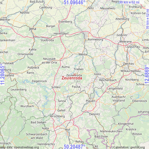
Zeulenroda GPS coordinates[2]
50° 39' 10.008" North, 11° 59' 1.572" East
| Map corner | latitude | longitude |
|---|---|---|
| Upper-left | 51.09646°, | 11.28065° |
| Center: | 50.65278°, | 11.98377° |
| Lower-right: | 50.20487°, | 12.6869° |
| Map W x H: | 99.1×99.1 km | = 61.6×61.6mi |
| max Lat: | 55.01917° ⇑49.1% North |
| Zeulenroda: | 50.65278° |
| min Lat: | ⇓50.9% South 47.40724° |
| min Long | Zeulenroda | max Long |
| 5.92978° | 11.98377° | 14.98853° |
| W 81.6%⇐ | ⇒18.4% E |
Elevation
Elevation of Zeulenroda is 411 m = 1348 ft, and this is 161.9 m = 531 ft above average elevation for this country.
| Max E: |
1256 m = 4121 ft | 23.2% |
| Zeulenroda | 411 m 1348 ft | |
| Avg. | 249.1 m = 817 ft | |
Min E: |
-5 m = -16 ft | 76.8% |
See also: Germany elevation on elevation.city.
Geographical zone
Zeulenroda is located in North temperate zone (between Tropic of Cancer and the Arctic Circle). Distance of this North polar circle is 1769.1 km =1099.3 mi to North.| Distance of | km | miles | from Zeulenroda |
|---|---|---|---|
| North Pole | 4375 | 2718.5 | to North |
| Arctic Circle | 1769.1 | 1099.3 | to North |
| Tropic Cancer | 3026.1 | 1880.3 | to South |
| Equator | 5632.1 | 3499.6 | to South |


Nearby cities:
15 places around Zeulenroda: (largest is in red/bold)
• Auma
8 km =5 mi,  311°
311°
• Chursdorf
9.6 km =6 mi,  279°
279°
• Göschitz
8.5 km =5.3 mi,  255°
255°
• Hain
9.3 km =5.8 mi,  49°
49°
• Hohenleuben
8.2 km =5.1 mi,  37°
37°
• Kirschkau
8.7 km =5.4 mi,  232°
232°
• Langenwetzendorf
8.3 km =5.2 mi,  69°
69°
• Langenwolschendorf
2.8 km =1.7 mi, 227°
• Lunzig
10.2 km =6.3 mi, 48°
• Löhma
10.4 km =6.5 mi,  243°
243°
• Pausa
8 km =5 mi,  173°
173°
• Reinsdorf
9.9 km =6.2 mi,  287°
287°
• Tegau
8.3 km =5.2 mi,  267°
267°
• Triebes
4.4 km =2.7 mi, 35°
• Weißendorf
3.6 km =2.2 mi,  18°
18°
Sources, notices
• [Note1] Compared only with cities in Germany existing in our database
• [Src1] Map data: © OpenStreetMap contributors (CC-BY-SA)
• [Src2] Other city data from geonames.org with taken over terms of usage.
• [Src3] Geographical zone / Annual Mean Temperature by Robert A. Rohde @ Wikipedia
