Biesenthal geodata
Biesenthal (Brandenburg) is a populated place; located in Germany in Europe/Berlin (GMT+2) time zone. With population of 5,512 people, there are 2624 cities with bigger population in this country. Compared to other cities in Germany, 80.1% of cities are located further ↓South; 96.6% of cities are located further ←West and 77.9% of cities have higher elevation than Biesenthal. Note1


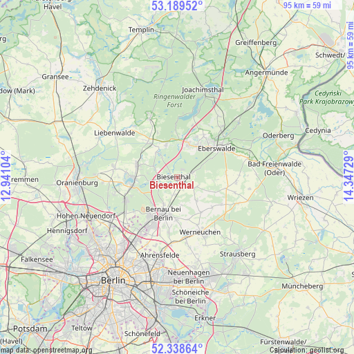
Biesenthal GPS coordinates[2]
52° 45' 58.176" North, 13° 38' 38.976" East
| Map corner | latitude | longitude |
|---|---|---|
| Upper-left | 53.18952°, | 12.94104° |
| Center: | 52.76616°, | 13.64416° |
| Lower-right: | 52.33864°, | 14.34729° |
| Map W x H: | 94.6×94.6 km | = 58.8×58.8mi |
| max Lat: | 55.01917° ⇑19.9% North |
| Biesenthal: | 52.76616° |
| min Lat: | ⇓80.1% South 47.40724° |
| min Long | Biesenthal | max Long |
| 5.92978° | 13.64416° | 14.98853° |
| W 96.6%⇐ | ⇒3.4% E |
Elevation
Elevation of Biesenthal is 53 m = 174 ft, and this is 196.1 m = 643 ft below average elevation for this country.
| Max E: |
1256 m = 4121 ft | 77.9% |
| Avg. | 249.1 m = 817 ft | |
| Biesenthal | 53 m = 174 ft | |
Min E: |
-5 m = -16 ft | 22.1% |
See also: Germany elevation on elevation.city.
Geographical zone
Biesenthal is located in North temperate zone (between Tropic of Cancer and the Arctic Circle). Distance of this North polar circle is 1534.1 km =953.2 mi to North.| Distance of | km | miles | from Biesenthal |
|---|---|---|---|
| North Pole | 4140 | 2572.5 | to North |
| Arctic Circle | 1534.1 | 953.2 | to North |
| Tropic Cancer | 3261.1 | 2026.4 | to South |
| Equator | 5867 | 3645.6 | to South |


Nearby cities:
15 places around Biesenthal: (largest is in red/bold)
• Bernau bei Berlin
10.3 km =6.4 mi,  201°
201°
• Britz
17.5 km =10.9 mi,  39°
39°
• Buch
17.7 km =11 mi,  214°
214°
• Eberswalde
14.1 km =8.8 mi,  57°
57°
• Golzow
19.6 km =12.2 mi,  34°
34°
• Hohenfinow
19.6 km =12.2 mi,  74°
74°
• Karow
20.6 km =12.8 mi, 212°
• Liebenwalde
20.4 km =12.7 mi,  304°
304°
• Marienwerder
9 km =5.6 mi,  340°
340°
• Melchow
4.3 km =2.7 mi,  75°
75°
• Niederfinow
20.5 km =12.7 mi, 68°
• Rüdnitz
5.1 km =3.2 mi,  194°
194°
• Wandlitz
12.8 km =8 mi,  257°
257°
• Werftpfuhl
15.5 km =9.6 mi,  139°
139°
• Werneuchen
16 km =9.9 mi,  157°
157°
Sources, notices
• [Note1] Compared only with cities in Germany existing in our database
• [Src1] Map data: © OpenStreetMap contributors (CC-BY-SA)
• [Src2] Other city data from geonames.org with taken over terms of usage.
• [Src3] Geographical zone / Annual Mean Temperature by Robert A. Rohde @ Wikipedia
