Hochspeyer geodata
Hochspeyer (Rheinland-Pfalz) is a seat of a fourth-order administrative division; located in Germany in Europe/Berlin (GMT+2) time zone. With population of 4,877 people, there are 2869 cities with bigger population in this country. Compared to other cities in Germany, 76.6% of cities are located further ↑North; 79.1% of cities are located further →East and 56.2% of cities have lower elevation than Hochspeyer. Note1
Administrative division(s):
- Level 1: Rheinland-Pfalz
- Level 3: Landkreis Kaiserslautern
- Level 4: Hochspeyer


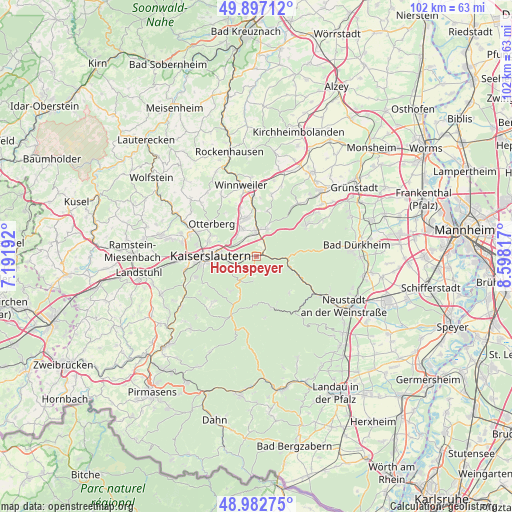
Hochspeyer GPS coordinates[2]
49° 26' 31.452" North, 7° 53' 42.144" East
| Map corner | latitude | longitude |
|---|---|---|
| Upper-left | 49.89712°, | 7.19192° |
| Center: | 49.44207°, | 7.89504° |
| Lower-right: | 48.98275°, | 8.59817° |
| Map W x H: | 101.7×101.7 km | = 63.2×63.2mi |
| max Lat: | 55.01917° ⇑76.6% North |
| Hochspeyer: | 49.44207° |
| min Lat: | ⇓23.4% South 47.40724° |
| min Long | Hochspeyer | max Long |
| 5.92978° | 7.89504° | 14.98853° |
| W 20.9%⇐ | ⇒79.1% E |
Elevation
Elevation of Hochspeyer is 267 m = 876 ft, and this is 17.9 m = 59 ft above average elevation for this country.
| Max E: |
1256 m = 4121 ft | 43.8% |
| Hochspeyer | 267 m 876 ft | |
| Avg. | 249.1 m = 817 ft | |
Min E: |
-5 m = -16 ft | 56.2% |
See also: Germany elevation on elevation.city.
Geographical zone
Hochspeyer is located in North temperate zone (between Tropic of Cancer and the Arctic Circle). Distance of this North polar circle is 1903.7 km =1182.9 mi to North.| Distance of | km | miles | from Hochspeyer |
|---|---|---|---|
| North Pole | 4509.6 | 2802.1 | to North |
| Arctic Circle | 1903.7 | 1182.9 | to North |
| Tropic Cancer | 2891.5 | 1796.7 | to South |
| Equator | 5497.4 | 3415.9 | to South |


Nearby cities:
15 places around Hochspeyer: (largest is in red/bold)
• Elmstein
8.8 km =5.5 mi,  161°
161°
• Enkenbach-Alsenborn
4.6 km =2.9 mi,  4°
4°
• Esthal
9.1 km =5.7 mi,  135°
135°
• Fischbach
1.8 km =1.1 mi,  60°
60°
• Frankenstein
6 km =3.7 mi,  92°
92°
• Gonbach
12 km =7.5 mi, 1°
• Kaiserslautern
8.9 km =5.5 mi,  270°
270°
• Mehlingen
6.2 km =3.9 mi,  331°
331°
• Münchweiler an der Alsenz
12 km =7.5 mi,  355°
355°
• Neuhemsbach
8.4 km =5.2 mi,  10°
10°
• Otterberg
11.3 km =7 mi,  306°
306°
• Sembach
8 km =5 mi,  345°
345°
• Waldleiningen
4.8 km =3 mi,  190°
190°
• Wartenberg-Rohrbach
10 km =6.2 mi,  342°
342°
• Weidenthal
8.1 km =5 mi,  110°
110°
Sources, notices
• [Note1] Compared only with cities in Germany existing in our database
• [Src1] Map data: © OpenStreetMap contributors (CC-BY-SA)
• [Src2] Other city data from geonames.org with taken over terms of usage.
• [Src3] Geographical zone / Annual Mean Temperature by Robert A. Rohde @ Wikipedia
