Weidenthal geodata
Weidenthal (Rheinland-Pfalz) is a seat of a fourth-order administrative division; located in Germany in Europe/Berlin (GMT+2) time zone. With population of 2,018 people, there are 5043 cities with bigger population in this country. Compared to other cities in Germany, 77% of cities are located further ↑North; 77.2% of cities are located further →East and 51.8% of cities have higher elevation than Weidenthal. Note1
Administrative division(s):
- Level 1: Rheinland-Pfalz
- Level 3: Landkreis Bad Dürkheim
- Level 4: Weidenthal


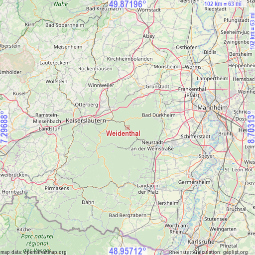
Weidenthal GPS coordinates[2]
49° 25' 0.012" North, 8° 0' 0" East
| Map corner | latitude | longitude |
|---|---|---|
| Upper-left | 49.87196°, | 7.29688° |
| Center: | 49.41667°, | 8° |
| Lower-right: | 48.95712°, | 8.70313° |
| Map W x H: | 101.7×101.7 km | = 63.2×63.2mi |
| max Lat: | 55.01917° ⇑77% North |
| Weidenthal: | 49.41667° |
| min Lat: | ⇓23% South 47.40724° |
| min Long | Weidenthal | max Long |
| 5.92978° | 8° | 14.98853° |
| W 22.8%⇐ | ⇒77.2% E |
Elevation
Elevation of Weidenthal is 213 m = 699 ft, and this is 36.1 m = 118 ft below average elevation for this country.
| Max E: |
1256 m = 4121 ft | 51.8% |
| Avg. | 249.1 m = 817 ft | |
| Weidenthal | 213 m = 699 ft | |
Min E: |
-5 m = -16 ft | 48.2% |
See also: Germany elevation on elevation.city.
Geographical zone
Weidenthal is located in North temperate zone (between Tropic of Cancer and the Arctic Circle). Distance of this North polar circle is 1906.6 km =1184.7 mi to North.| Distance of | km | miles | from Weidenthal |
|---|---|---|---|
| North Pole | 4512.4 | 2803.9 | to North |
| Arctic Circle | 1906.6 | 1184.7 | to North |
| Tropic Cancer | 2888.7 | 1795 | to South |
| Equator | 5494.6 | 3414.2 | to South |


Nearby cities:
15 places around Weidenthal: (largest is in red/bold)
• Altleiningen
11.4 km =7.1 mi,  27°
27°
• Carlsberg
10.2 km =6.3 mi,  17°
17°
• Elmstein
7.4 km =4.6 mi,  220°
220°
• Enkenbach-Alsenborn
10.4 km =6.5 mi,  315°
315°
• Esthal
3.9 km =2.4 mi,  198°
198°
• Fischbach
7.1 km =4.4 mi,  301°
301°
• Frankeneck
5.7 km =3.5 mi,  141°
141°
• Frankenstein
3.1 km =1.9 mi,  327°
327°
• Hochspeyer
8.1 km =5 mi,  290°
290°
• Lambrecht
7.3 km =4.5 mi,  134°
134°
• Lindenberg
8.2 km =5.1 mi,  119°
119°
• Neidenfels
4.6 km =2.9 mi, 132°
• Neustadt
12.5 km =7.8 mi, 126°
• Waldleiningen
8.6 km =5.3 mi,  257°
257°
• Wattenheim
12.5 km =7.8 mi, 20°
Sources, notices
• [Note1] Compared only with cities in Germany existing in our database
• [Src1] Map data: © OpenStreetMap contributors (CC-BY-SA)
• [Src2] Other city data from geonames.org with taken over terms of usage.
• [Src3] Geographical zone / Annual Mean Temperature by Robert A. Rohde @ Wikipedia
