Hochheim geodata
Hochheim (Thuringia) is a seat of a fourth-order administrative division; located in Germany in Europe/Berlin (GMT+2) time zone. In our database, there are 11009 cities with bigger population. Compared to other cities in Germany, 58.3% of cities are located further ↓South; 61.9% of cities are located further ←West and 58.8% of cities have lower elevation than Hochheim. Note1


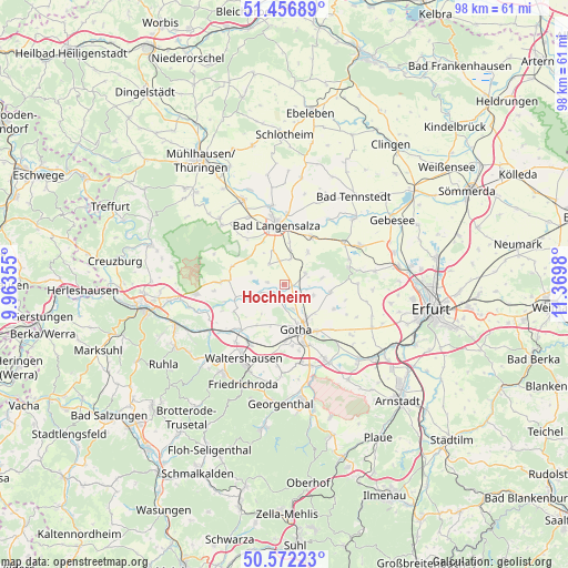
Hochheim GPS coordinates[2]
51° 1' 0.012" North, 10° 40' 0.012" East
| Map corner | latitude | longitude |
|---|---|---|
| Upper-left | 51.45689°, | 9.96355° |
| Center: | 51.01667°, | 10.66667° |
| Lower-right: | 50.57223°, | 11.3698° |
| Map W x H: | 98.4×98.4 km | = 61.1×61.1mi |
| max Lat: | 55.01917° ⇑41.7% North |
| Hochheim: | 51.01667° |
| min Lat: | ⇓58.3% South 47.40724° |
| min Long | Hochheim | max Long |
| 5.92978° | 10.66667° | 14.98853° |
| W 61.9%⇐ | ⇒38.1% E |
Elevation
Elevation of Hochheim is 283 m = 928 ft, and this is 33.9 m = 111 ft above average elevation for this country.
| Max E: |
1256 m = 4121 ft | 41.2% |
| Hochheim | 283 m 928 ft | |
| Avg. | 249.1 m = 817 ft | |
Min E: |
-5 m = -16 ft | 58.8% |
See also: Germany elevation on elevation.city.
Geographical zone
Hochheim is located in North temperate zone (between Tropic of Cancer and the Arctic Circle). Distance of this North polar circle is 1728.7 km =1074.2 mi to North.| Distance of | km | miles | from Hochheim |
|---|---|---|---|
| North Pole | 4334.5 | 2693.3 | to North |
| Arctic Circle | 1728.7 | 1074.2 | to North |
| Tropic Cancer | 3066.6 | 1905.5 | to South |
| Equator | 5672.5 | 3524.7 | to South |


Nearby cities:
15 places around Hochheim: (largest is in red/bold)
• Bad Langensalza
10.2 km =6.3 mi,  351°
351°
• Ballstädt
4 km =2.5 mi,  62°
62°
• Brüheim
6.1 km =3.8 mi,  252°
252°
• Bufleben
5 km =3.1 mi,  111°
111°
• Eschenbergen
6.6 km =4.1 mi,  80°
80°
• Friedrichswerth
8.9 km =5.5 mi, 253°
• Friemar
9.6 km =6 mi,  117°
117°
• Goldbach
2.8 km =1.7 mi,  193°
193°
• Gotha
8 km =5 mi,  162°
162°
• Molschleben
8.4 km =5.2 mi,  102°
102°
• Remstädt
4.4 km =2.7 mi, 160°
• Sonneborn
5.9 km =3.7 mi,  243°
243°
• Wangenheim
3 km =1.9 mi,  276°
276°
• Warza
2.2 km =1.4 mi,  147°
147°
• Westhausen
1.2 km =0.7 mi,  90°
90°
Sources, notices
• [Note1] Compared only with cities in Germany existing in our database
• [Src1] Map data: © OpenStreetMap contributors (CC-BY-SA)
• [Src2] Other city data from geonames.org with taken over terms of usage.
• [Src3] Geographical zone / Annual Mean Temperature by Robert A. Rohde @ Wikipedia
