Goldbach geodata
Goldbach (Thuringia) is a seat of a fourth-order administrative division; located in Germany in Europe/Berlin (GMT+2) time zone. In our database, there are 11009 cities with bigger population. Compared to other cities in Germany, 58% of cities are located further ↓South; 61.8% of cities are located further ←West and 57.5% of cities have lower elevation than Goldbach. Note1


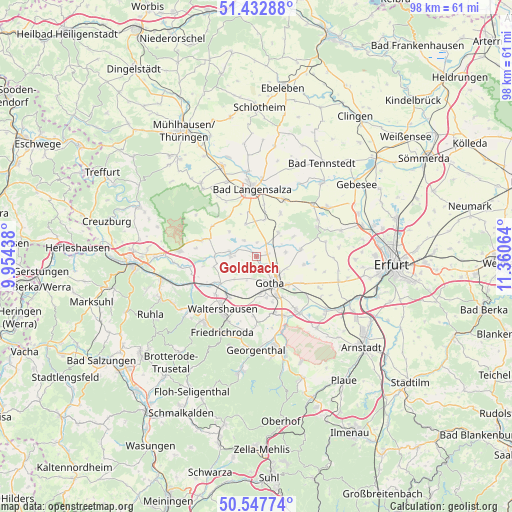
Goldbach GPS coordinates[2]
50° 59' 32.712" North, 10° 39' 27.036" East
| Map corner | latitude | longitude |
|---|---|---|
| Upper-left | 51.43288°, | 9.95438° |
| Center: | 50.99242°, | 10.65751° |
| Lower-right: | 50.54774°, | 11.36064° |
| Map W x H: | 98.4×98.4 km | = 61.1×61.1mi |
| max Lat: | 55.01917° ⇑42% North |
| Goldbach: | 50.99242° |
| min Lat: | ⇓58% South 47.40724° |
| min Long | Goldbach | max Long |
| 5.92978° | 10.65751° | 14.98853° |
| W 61.8%⇐ | ⇒38.2% E |
Elevation
Elevation of Goldbach is 275 m = 902 ft, and this is 25.9 m = 85 ft above average elevation for this country.
| Max E: |
1256 m = 4121 ft | 42.5% |
| Goldbach | 275 m 902 ft | |
| Avg. | 249.1 m = 817 ft | |
Min E: |
-5 m = -16 ft | 57.5% |
See also: Germany elevation on elevation.city.
Geographical zone
Goldbach is located in North temperate zone (between Tropic of Cancer and the Arctic Circle). Distance of this North polar circle is 1731.3 km =1075.8 mi to North.| Distance of | km | miles | from Goldbach |
|---|---|---|---|
| North Pole | 4337.2 | 2695 | to North |
| Arctic Circle | 1731.3 | 1075.8 | to North |
| Tropic Cancer | 3063.9 | 1903.8 | to South |
| Equator | 5669.8 | 3523 | to South |


Nearby cities:
15 places around Goldbach: (largest is in red/bold)
• Ballstädt
6.1 km =3.8 mi,  42°
42°
• Brüheim
5.3 km =3.3 mi,  279°
279°
• Bufleben
5.4 km =3.4 mi,  80°
80°
• Eschenbergen
8.1 km =5 mi,  61°
61°
• Friedrichswerth
7.9 km =4.9 mi,  271°
271°
• Friemar
9.3 km =5.8 mi,  100°
100°
• Gotha
5.8 km =3.6 mi,  147°
147°
• Hochheim
2.8 km =1.7 mi,  13°
13°
• Hörselgau
9.6 km =6 mi,  212°
212°
• Molschleben
8.8 km =5.5 mi, 84°
• Remstädt
2.6 km =1.6 mi,  125°
125°
• Sonneborn
4.6 km =2.9 mi, 270°
• Wangenheim
3.8 km =2.4 mi,  322°
322°
• Warza
2 km =1.2 mi, 64°
• Westhausen
3.2 km =2 mi,  33°
33°
Sources, notices
• [Note1] Compared only with cities in Germany existing in our database
• [Src1] Map data: © OpenStreetMap contributors (CC-BY-SA)
• [Src2] Other city data from geonames.org with taken over terms of usage.
• [Src3] Geographical zone / Annual Mean Temperature by Robert A. Rohde @ Wikipedia
