Sonneborn geodata
Sonneborn (Thuringia) is a seat of a fourth-order administrative division; located in Germany in Europe/Berlin (GMT+2) time zone. With population of 1,283 people, there are 6354 cities with bigger population in this country. Compared to other cities in Germany, 58% of cities are located further ↓South; 60.6% of cities are located further ←West and 55.7% of cities have lower elevation than Sonneborn. Note1


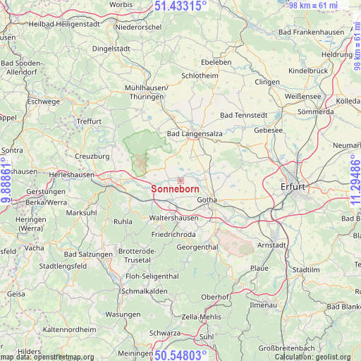
Sonneborn GPS coordinates[2]
50° 59' 33.72" North, 10° 35' 30.228" East
| Map corner | latitude | longitude |
|---|---|---|
| Upper-left | 51.43315°, | 9.88861° |
| Center: | 50.9927°, | 10.59173° |
| Lower-right: | 50.54803°, | 11.29486° |
| Map W x H: | 98.4×98.4 km | = 61.1×61.1mi |
| max Lat: | 55.01917° ⇑42% North |
| Sonneborn: | 50.9927° |
| min Lat: | ⇓58% South 47.40724° |
| min Long | Sonneborn | max Long |
| 5.92978° | 10.59173° | 14.98853° |
| W 60.6%⇐ | ⇒39.4% E |
Elevation
Elevation of Sonneborn is 263 m = 863 ft, and this is 13.9 m = 46 ft above average elevation for this country.
| Max E: |
1256 m = 4121 ft | 44.3% |
| Sonneborn | 263 m 863 ft | |
| Avg. | 249.1 m = 817 ft | |
Min E: |
-5 m = -16 ft | 55.7% |
See also: Germany elevation on elevation.city.
Geographical zone
Sonneborn is located in North temperate zone (between Tropic of Cancer and the Arctic Circle). Distance of this North polar circle is 1731.3 km =1075.8 mi to North.| Distance of | km | miles | from Sonneborn |
|---|---|---|---|
| North Pole | 4337.2 | 2695 | to North |
| Arctic Circle | 1731.3 | 1075.8 | to North |
| Tropic Cancer | 3063.9 | 1903.8 | to South |
| Equator | 5669.9 | 3523.1 | to South |


Nearby cities:
15 places around Sonneborn: (largest is in red/bold)
• Ballstädt
9.8 km =6.1 mi,  62°
62°
• Brüheim
1 km =0.6 mi,  324°
324°
• Bufleben
9.9 km =6.2 mi,  85°
85°
• Friedrichswerth
3.3 km =2.1 mi,  272°
272°
• Goldbach
4.6 km =2.9 mi, 90°
• Gotha
9.2 km =5.7 mi,  122°
122°
• Haina
5.2 km =3.2 mi, 266°
• Hochheim
5.9 km =3.7 mi, 63°
• Hörselgau
8.1 km =5 mi,  183°
183°
• Laucha
8.2 km =5.1 mi,  204°
204°
• Mechterstädt
7.4 km =4.6 mi,  220°
220°
• Remstädt
6.9 km =4.3 mi,  102°
102°
• Wangenheim
3.8 km =2.4 mi,  37°
37°
• Warza
6.5 km =4 mi,  82°
82°
• Westhausen
6.9 km =4.3 mi,  67°
67°
Sources, notices
• [Note1] Compared only with cities in Germany existing in our database
• [Src1] Map data: © OpenStreetMap contributors (CC-BY-SA)
• [Src2] Other city data from geonames.org with taken over terms of usage.
• [Src3] Geographical zone / Annual Mean Temperature by Robert A. Rohde @ Wikipedia
