Hillscheid geodata
Hillscheid (Rheinland-Pfalz) is a seat of a fourth-order administrative division; located in Germany in Europe/Berlin (GMT+2) time zone. With population of 2,691 people, there are 4239 cities with bigger population in this country. Compared to other cities in Germany, 54.5% of cities are located further ↑North; 83.1% of cities are located further →East and 64.9% of cities have lower elevation than Hillscheid. Note1


Hillscheid GPS coordinates[2]
50° 24' 23.004" North, 7° 41' 54.996" East
| Map corner | latitude | longitude |
|---|---|---|
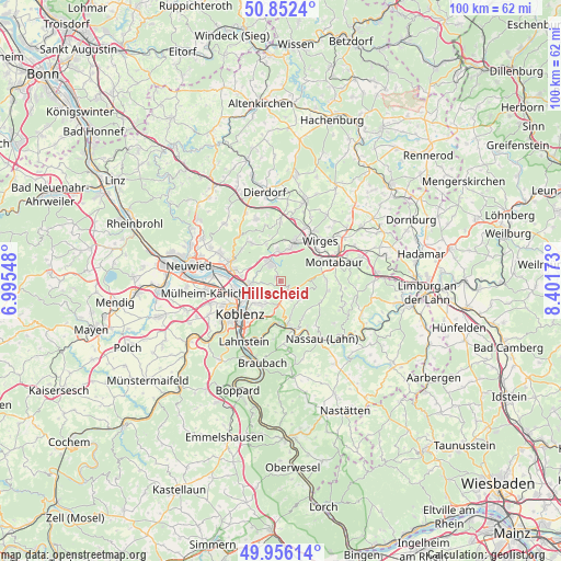
| Upper-left | 50.8524°, | 6.99548° |
| Center: | 50.40639°, | 7.69861° |
| Lower-right: | 49.95614°, | 8.40173° |
| Map W x H: | 99.7×99.7 km | = 62×62mi |
| max Lat: | 55.01917° ⇑54.5% North |
| Hillscheid: | 50.40639° |
| min Lat: | ⇓45.5% South 47.40724° |
| min Long | Hillscheid | max Long |
| 5.92978° | 7.69861° | 14.98853° |
| W 16.9%⇐ | ⇒83.1% E |
Elevation
Elevation of Hillscheid is 320 m = 1050 ft, and this is 70.9 m = 233 ft above average elevation for this country.
| Max E: |
1256 m = 4121 ft | 35.1% |
| Hillscheid | 320 m 1050 ft | |
| Avg. | 249.1 m = 817 ft | |
Min E: |
-5 m = -16 ft | 64.9% |
See also: Germany elevation on elevation.city.
Geographical zone
Hillscheid is located in North temperate zone (between Tropic of Cancer and the Arctic Circle). Distance of this North polar circle is 1796.5 km =1116.3 mi to North.| Distance of | km | miles | from Hillscheid |
|---|---|---|---|
| North Pole | 4402.4 | 2735.5 | to North |
| Arctic Circle | 1796.5 | 1116.3 | to North |
| Tropic Cancer | 2998.7 | 1863.3 | to South |
| Equator | 5604.7 | 3482.6 | to South |


Nearby cities:
15 places around Hillscheid: (largest is in red/bold)
• Alsbach
6.9 km =4.3 mi,  337°
337°
• Arzbach
4.7 km =2.9 mi,  130°
130°
• Eitelborn
3.6 km =2.2 mi,  150°
150°
• Hilgert
5.6 km =3.5 mi,  351°
351°
• Hundsdorf
7.1 km =4.4 mi,  2°
2°
• Höhr-Grenzhausen
3.8 km =2.4 mi,  326°
326°
• Kadenbach
3.6 km =2.2 mi,  136°
136°
• Kammerforst
6.5 km =4 mi, 345°
• Neuhäusel
2.7 km =1.7 mi,  162°
162°
• Niederwerth
5.9 km =3.7 mi,  263°
263°
• Ransbach-Baumbach
6.8 km =4.2 mi,  17°
17°
• Simmern
2.6 km =1.6 mi,  222°
222°
• Urbar
5.3 km =3.3 mi,  241°
241°
• Vallendar
5.4 km =3.4 mi, 257°
• Weitersburg
7.1 km =4.4 mi,  279°
279°
Sources, notices
• [Note1] Compared only with cities in Germany existing in our database
• [Src1] Map data: © OpenStreetMap contributors (CC-BY-SA)
• [Src2] Other city data from geonames.org with taken over terms of usage.
• [Src3] Geographical zone / Annual Mean Temperature by Robert A. Rohde @ Wikipedia
