Hilgert geodata
Hilgert (Rheinland-Pfalz) is a seat of a fourth-order administrative division; located in Germany in Europe/Berlin (GMT+2) time zone. With population of 1,448 people, there are 5981 cities with bigger population in this country. Compared to other cities in Germany, 53.6% of cities are located further ↑North; 83.2% of cities are located further →East and 65.1% of cities have lower elevation than Hilgert. Note1


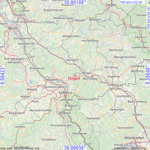
Hilgert GPS coordinates[2]
50° 27' 22.824" North, 7° 41' 14.46" East
| Map corner | latitude | longitude |
|---|---|---|
| Upper-left | 50.90188°, | 6.98423° |
| Center: | 50.45634°, | 7.68735° |
| Lower-right: | 50.00656°, | 8.39048° |
| Map W x H: | 99.6×99.5 km | = 61.9×61.8mi |
| max Lat: | 55.01917° ⇑53.6% North |
| Hilgert: | 50.45634° |
| min Lat: | ⇓46.4% South 47.40724° |
| min Long | Hilgert | max Long |
| 5.92978° | 7.68735° | 14.98853° |
| W 16.8%⇐ | ⇒83.2% E |
Elevation
Elevation of Hilgert is 322 m = 1056 ft, and this is 72.9 m = 239 ft above average elevation for this country.
| Max E: |
1256 m = 4121 ft | 34.9% |
| Hilgert | 322 m 1056 ft | |
| Avg. | 249.1 m = 817 ft | |
Min E: |
-5 m = -16 ft | 65.1% |
See also: Germany elevation on elevation.city.
Geographical zone
Hilgert is located in North temperate zone (between Tropic of Cancer and the Arctic Circle). Distance of this North polar circle is 1791 km =1112.9 mi to North.| Distance of | km | miles | from Hilgert |
|---|---|---|---|
| North Pole | 4396.8 | 2732 | to North |
| Arctic Circle | 1791 | 1112.9 | to North |
| Tropic Cancer | 3004.3 | 1866.8 | to South |
| Equator | 5610.2 | 3486 | to South |


Nearby cities:
15 places around Hilgert: (largest is in red/bold)
• Alsbach
2 km =1.2 mi,  295°
295°
• Breitenau
4.6 km =2.9 mi,  2°
2°
• Caan
5.1 km =3.2 mi,  282°
282°
• Deesen
6.1 km =3.8 mi,  8°
8°
• Ebernhahn
6.1 km =3.8 mi,  72°
72°
• Hillscheid
5.6 km =3.5 mi,  171°
171°
• Hundsdorf
1.9 km =1.2 mi,  34°
34°
• Höhr-Grenzhausen
2.7 km =1.7 mi,  208°
208°
• Kammerforst
1.1 km =0.7 mi,  312°
312°
• Kausen
4.9 km =3 mi,  334°
334°
• Nauort
4 km =2.5 mi,  286°
286°
• Ransbach-Baumbach
3.1 km =1.9 mi, 71°
• Sessenbach
3.8 km =2.4 mi, 307°
• Wirscheid
1.9 km =1.2 mi, 308°
• Wittgert
4.9 km =3 mi, 10°
Sources, notices
• [Note1] Compared only with cities in Germany existing in our database
• [Src1] Map data: © OpenStreetMap contributors (CC-BY-SA)
• [Src2] Other city data from geonames.org with taken over terms of usage.
• [Src3] Geographical zone / Annual Mean Temperature by Robert A. Rohde @ Wikipedia
