Heusweiler geodata
Heusweiler (Saarland) is a seat of a fourth-order administrative division; located in Germany in Europe/Berlin (GMT+2) time zone. With population of 20,006 people, there are 780 cities with bigger population in this country. Compared to other cities in Germany, 78.1% of cities are located further ↑North; 94.2% of cities are located further →East and 50.3% of cities have lower elevation than Heusweiler. Note1
Administrative division(s):
- Level 1: Saarland
- Level 3: Regionalverband Saarbrücken
- Level 4: Heusweiler


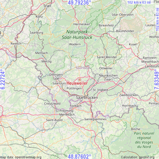
Heusweiler GPS coordinates[2]
49° 20' 10.752" North, 6° 55' 49.296" East
| Map corner | latitude | longitude |
|---|---|---|
| Upper-left | 49.79236°, | 6.22724° |
| Center: | 49.33632°, | 6.93036° |
| Lower-right: | 48.87602°, | 7.63349° |
| Map W x H: | 101.9×101.9 km | = 63.3×63.3mi |
| max Lat: | 55.01917° ⇑78.1% North |
| Heusweiler: | 49.33632° |
| min Lat: | ⇓21.9% South 47.40724° |
| min Long | Heusweiler | max Long |
| 5.92978° | 6.93036° | 14.98853° |
| W 5.8%⇐ | ⇒94.2% E |
Elevation
Elevation of Heusweiler is 228 m = 748 ft, and this is 21.1 m = 69 ft below average elevation for this country.
| Max E: |
1256 m = 4121 ft | 49.7% |
| Avg. | 249.1 m = 817 ft | |
| Heusweiler | 228 m = 748 ft | |
Min E: |
-5 m = -16 ft | 50.3% |
See also: Germany elevation on elevation.city.
Geographical zone
Heusweiler is located in North temperate zone (between Tropic of Cancer and the Arctic Circle). Distance of this North polar circle is 1915.5 km =1190.2 mi to North.| Distance of | km | miles | from Heusweiler |
|---|---|---|---|
| North Pole | 4521.4 | 2809.5 | to North |
| Arctic Circle | 1915.5 | 1190.2 | to North |
| Tropic Cancer | 2879.8 | 1789.4 | to South |
| Equator | 5485.7 | 3408.7 | to South |


Nearby cities:
15 places around Heusweiler: (largest is in red/bold)
• Eppelborn
7.6 km =4.7 mi,  20°
20°
• Fenne
10.5 km =6.5 mi,  198°
198°
• Heidstock
9.6 km =6 mi, 201°
• Illingen
9.4 km =5.8 mi,  63°
63°
• Lebach
8.5 km =5.3 mi,  349°
349°
• Luisenthal
9.9 km =6.2 mi,  192°
192°
• Merchweiler
8.8 km =5.5 mi,  80°
80°
• Püttlingen
6.5 km =4 mi,  208°
208°
• Quierschied
8.9 km =5.5 mi,  104°
104°
• Riegelsberg
4 km =2.5 mi,  176°
176°
• Röchling-Höhe
10 km =6.2 mi,  223°
223°
• Saarwellingen
9.3 km =5.8 mi,  282°
282°
• Schwalbach
9.2 km =5.7 mi,  243°
243°
• Sulzbach
10.1 km =6.3 mi,  114°
114°
• Völklingen
10.8 km =6.7 mi, 208°
Sources, notices
• [Note1] Compared only with cities in Germany existing in our database
• [Src1] Map data: © OpenStreetMap contributors (CC-BY-SA)
• [Src2] Other city data from geonames.org with taken over terms of usage.
• [Src3] Geographical zone / Annual Mean Temperature by Robert A. Rohde @ Wikipedia
