Illingen geodata
Illingen (Saarland) is a populated place; located in Germany in Europe/Berlin (GMT+2) time zone. With population of 18,488 people, there are 849 cities with bigger population in this country. Compared to other cities in Germany, 77.6% of cities are located further ↑North; 92.8% of cities are located further →East and 60.7% of cities have lower elevation than Illingen. Note1
Administrative division(s):
- Level 1: Saarland
- Level 3: Landkreis Neunkirchen
- Level 4: Illingen / Saar


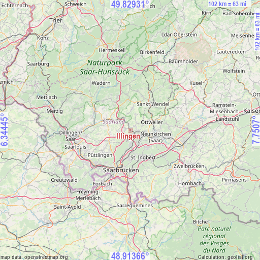
Illingen GPS coordinates[2]
49° 22' 25.032" North, 7° 2' 51.288" East
| Map corner | latitude | longitude |
|---|---|---|
| Upper-left | 49.82931°, | 6.34445° |
| Center: | 49.37362°, | 7.04758° |
| Lower-right: | 48.91366°, | 7.7507° |
| Map W x H: | 101.8×101.8 km | = 63.3×63.3mi |
| max Lat: | 55.01917° ⇑77.6% North |
| Illingen: | 49.37362° |
| min Lat: | ⇓22.4% South 47.40724° |
| min Long | Illingen | max Long |
| 5.92978° | 7.04758° | 14.98853° |
| W 7.2%⇐ | ⇒92.8% E |
Elevation
Elevation of Illingen is 294 m = 965 ft, and this is 44.9 m = 147 ft above average elevation for this country.
| Max E: |
1256 m = 4121 ft | 39.3% |
| Illingen | 294 m 965 ft | |
| Avg. | 249.1 m = 817 ft | |
Min E: |
-5 m = -16 ft | 60.7% |
See also: Germany elevation on elevation.city.
Geographical zone
Illingen is located in North temperate zone (between Tropic of Cancer and the Arctic Circle). Distance of this North polar circle is 1911.3 km =1187.6 mi to North.| Distance of | km | miles | from Illingen |
|---|---|---|---|
| North Pole | 4517.2 | 2806.9 | to North |
| Arctic Circle | 1911.3 | 1187.6 | to North |
| Tropic Cancer | 2883.9 | 1792 | to South |
| Equator | 5489.8 | 3411.2 | to South |


Nearby cities:
15 places around Illingen: (largest is in red/bold)
• Eppelborn
6.5 km =4 mi,  296°
296°
• Friedrichsthal
6.2 km =3.9 mi,  145°
145°
• Hangard
11.8 km =7.3 mi,  85°
85°
• Heusweiler
9.4 km =5.8 mi,  243°
243°
• Lebach
10.8 km =6.7 mi,  292°
292°
• Mainzweiler
7 km =4.3 mi,  46°
46°
• Marpingen
8.8 km =5.5 mi,  5°
5°
• Merchweiler
2.6 km =1.6 mi,  176°
176°
• Neunkirchen
10.2 km =6.3 mi,  108°
108°
• Ottweiler
9 km =5.6 mi,  69°
69°
• Quierschied
6.3 km =3.9 mi, 178°
• Riegelsberg
11.6 km =7.2 mi,  225°
225°
• Schiffweiler
6.3 km =3.9 mi,  97°
97°
• Spiesen-Elversberg
8.9 km =5.5 mi,  135°
135°
• Sulzbach
8.3 km =5.2 mi, 175°
Sources, notices
• [Note1] Compared only with cities in Germany existing in our database
• [Src1] Map data: © OpenStreetMap contributors (CC-BY-SA)
• [Src2] Other city data from geonames.org with taken over terms of usage.
• [Src3] Geographical zone / Annual Mean Temperature by Robert A. Rohde @ Wikipedia
