Lebach geodata
Lebach (Saarland) is a populated place; located in Germany in Europe/Berlin (GMT+2) time zone. With population of 21,583 people, there are 701 cities with bigger population in this country. Compared to other cities in Germany, 77% of cities are located further ↑North; 94.4% of cities are located further →East and 50.5% of cities have higher elevation than Lebach. Note1


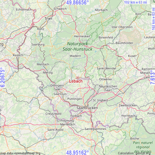
Lebach GPS coordinates[2]
49° 24' 40.392" North, 6° 54' 35.568" East
| Map corner | latitude | longitude |
|---|---|---|
| Upper-left | 49.86656°, | 6.20675° |
| Center: | 49.41122°, | 6.90988° |
| Lower-right: | 48.95162°, | 7.613° |
| Map W x H: | 101.7×101.7 km | = 63.2×63.2mi |
| max Lat: | 55.01917° ⇑77% North |
| Lebach: | 49.41122° |
| min Lat: | ⇓23% South 47.40724° |
| min Long | Lebach | max Long |
| 5.92978° | 6.90988° | 14.98853° |
| W 5.6%⇐ | ⇒94.4% E |
Elevation
Elevation of Lebach is 221 m = 725 ft, and this is 28.1 m = 92 ft below average elevation for this country.
| Max E: |
1256 m = 4121 ft | 50.5% |
| Avg. | 249.1 m = 817 ft | |
| Lebach | 221 m = 725 ft | |
Min E: |
-5 m = -16 ft | 49.5% |
See also: Germany elevation on elevation.city.
Geographical zone
Lebach is located in North temperate zone (between Tropic of Cancer and the Arctic Circle). Distance of this North polar circle is 1907.2 km =1185.1 mi to North.| Distance of | km | miles | from Lebach |
|---|---|---|---|
| North Pole | 4513 | 2804.2 | to North |
| Arctic Circle | 1907.2 | 1185.1 | to North |
| Tropic Cancer | 2888.1 | 1794.6 | to South |
| Equator | 5494 | 3413.8 | to South |


Nearby cities:
15 places around Lebach: (largest is in red/bold)
• Dillingen
14.6 km =9.1 mi,  244°
244°
• Eppelborn
4.3 km =2.7 mi,  106°
106°
• Heusweiler
8.5 km =5.3 mi,  169°
169°
• Illingen
10.8 km =6.7 mi, 112°
• Marpingen
11.7 km =7.3 mi,  66°
66°
• Merchweiler
12.2 km =7.6 mi,  123°
123°
• Nalbach
9.7 km =6 mi,  251°
251°
• Püttlingen
14.1 km =8.8 mi,  186°
186°
• Quierschied
14.6 km =9.1 mi,  136°
136°
• Riegelsberg
12.5 km =7.8 mi, 172°
• Saarwellingen
9.9 km =6.2 mi,  230°
230°
• Schmelz
5 km =3.1 mi,  299°
299°
• Schwalbach
14.1 km =8.8 mi,  208°
208°
• Tholey
12.2 km =7.6 mi,  48°
48°
• Wadern
14.5 km =9 mi,  353°
353°
Sources, notices
• [Note1] Compared only with cities in Germany existing in our database
• [Src1] Map data: © OpenStreetMap contributors (CC-BY-SA)
• [Src2] Other city data from geonames.org with taken over terms of usage.
• [Src3] Geographical zone / Annual Mean Temperature by Robert A. Rohde @ Wikipedia
