Sülzfeld geodata
Sülzfeld (Thuringia) is a seat of a fourth-order administrative division; located in Germany in Europe/Berlin (GMT+2) time zone. With population of 947 people, there are 7359 cities with bigger population in this country. Compared to other cities in Germany, 52.3% of cities are located further ↑North; 56.5% of cities are located further ←West and 64.7% of cities have lower elevation than Sülzfeld. Note1
Administrative division(s):
- Level 1: Thuringia
- Level 3: Landkreis Schmalkalden-Meiningen
- Level 4: Sülzfeld


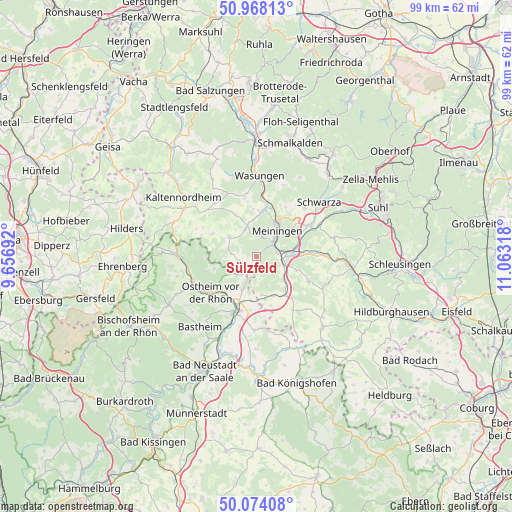
Sülzfeld GPS coordinates[2]
50° 31' 23.592" North, 10° 21' 36.18" East
| Map corner | latitude | longitude |
|---|---|---|
| Upper-left | 50.96813°, | 9.65692° |
| Center: | 50.52322°, | 10.36005° |
| Lower-right: | 50.07408°, | 11.06318° |
| Map W x H: | 99.4×99.4 km | = 61.8×61.8mi |
| max Lat: | 55.01917° ⇑52.3% North |
| Sülzfeld: | 50.52322° |
| min Lat: | ⇓47.7% South 47.40724° |
| min Long | Sülzfeld | max Long |
| 5.92978° | 10.36005° | 14.98853° |
| W 56.5%⇐ | ⇒43.5% E |
Elevation
Elevation of Sülzfeld is 319 m = 1047 ft, and this is 69.9 m = 229 ft above average elevation for this country.
| Max E: |
1256 m = 4121 ft | 35.3% |
| Sülzfeld | 319 m 1047 ft | |
| Avg. | 249.1 m = 817 ft | |
Min E: |
-5 m = -16 ft | 64.7% |
See also: Germany elevation on elevation.city.
Geographical zone
Sülzfeld is located in North temperate zone (between Tropic of Cancer and the Arctic Circle). Distance of this North polar circle is 1783.5 km =1108.2 mi to North.| Distance of | km | miles | from Sülzfeld |
|---|---|---|---|
| North Pole | 4389.4 | 2727.4 | to North |
| Arctic Circle | 1783.5 | 1108.2 | to North |
| Tropic Cancer | 3011.7 | 1871.4 | to South |
| Equator | 5617.7 | 3490.7 | to South |


Nearby cities:
15 places around Sülzfeld: (largest is in red/bold)
• Bibra
8.2 km =5.1 mi,  136°
136°
• Einhausen
7.2 km =4.5 mi,  85°
85°
• Ellingshausen
8.1 km =5 mi,  68°
68°
• Henneberg
3.4 km =2.1 mi,  186°
186°
• Herpf
6.4 km =4 mi,  342°
342°
• Meiningen
6.3 km =3.9 mi,  38°
38°
• Neubrunn
8 km =5 mi,  108°
108°
• Obermaßfeld-Grimmenthal
5.7 km =3.5 mi,  83°
83°
• Rippershausen
8.6 km =5.3 mi,  355°
355°
• Ritschenhausen
5.3 km =3.3 mi, 105°
• Stepfershausen
9.5 km =5.9 mi,  333°
333°
• Stockheim
9.4 km =5.8 mi,  221°
221°
• Untermaßfeld
4.2 km =2.6 mi, 74°
• Willmars
8.2 km =5.1 mi,  251°
251°
• Wölfershausen
6.8 km =4.2 mi,  130°
130°
Sources, notices
• [Note1] Compared only with cities in Germany existing in our database
• [Src1] Map data: © OpenStreetMap contributors (CC-BY-SA)
• [Src2] Other city data from geonames.org with taken over terms of usage.
• [Src3] Geographical zone / Annual Mean Temperature by Robert A. Rohde @ Wikipedia
